Hi,
We are currently working on supporting more cameras, unfortunately P4 Pro Advance is not yet directly supported, only trough XML.
Best
Hi,
We are currently working on supporting more cameras, unfortunately P4 Pro Advance is not yet directly supported, only trough XML.
Best
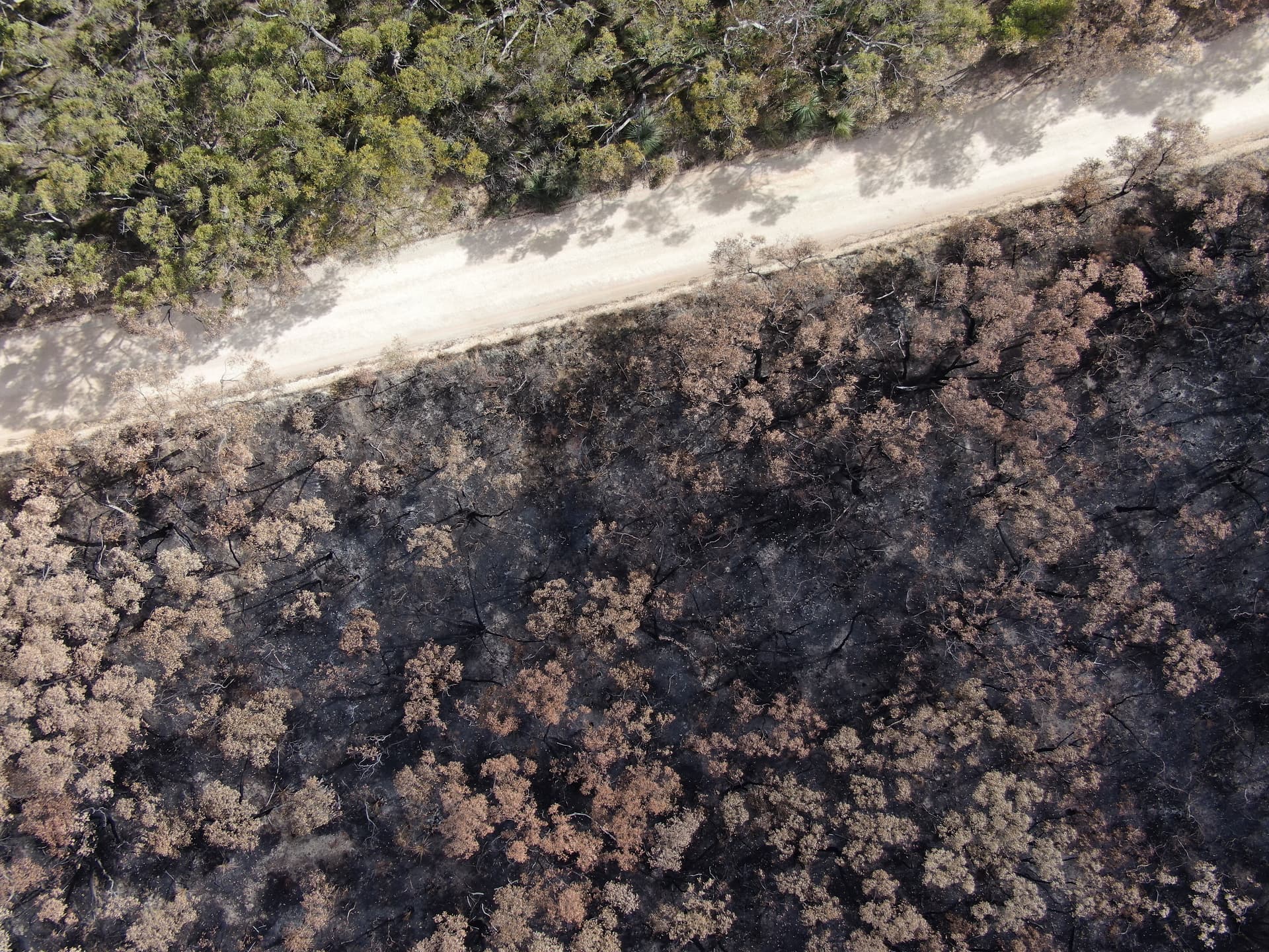
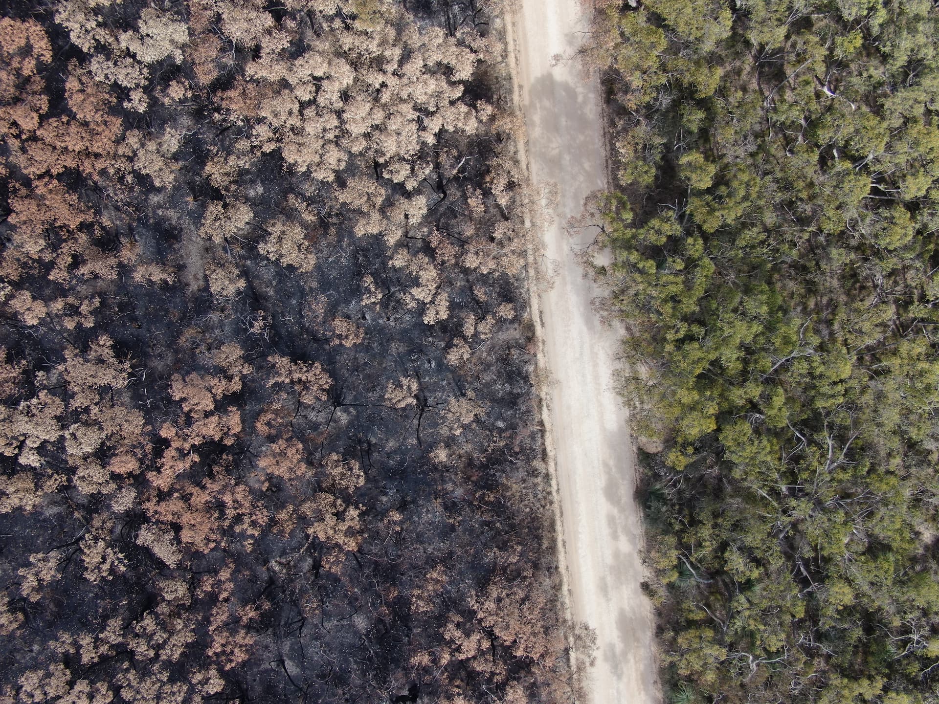
I use the Mavic 2 Pro setup in HQ mode for the camera. The camera profile built into the camera database is setup for this camera with full FOV. I created a XML that works but not sure if it is correct. Can someone verify if I share some images?
Using the Mavic 2 Pro on a recent flight, I captured 400+ images, I am getting missing areas in the map using the camera profile I setup. I don’t know if the missing area is because of the profile or something else. Is it possible for someone to help me figure out why the map is missing areas?
José Armando,
Technichal Support
Pix4D
La solución es cambiar la resolución, el problema es que estaba a una resolución de 5472x3078 la cual ya fue removida dentro de las cámaras soportadas por Pix4DFields en la última publicación de su sitio web, simplemente la cambia por 3:2 (5472x3648) y ya está funcionando sin problema.
Saludos desde México
Gracias!
Hi,
Claro estaba confundido! diferente resolucion entonces.
Gracias por aclarar.
Un saludo!
Hi,
If it’s working and you don’t see anything really strange on the images should be fine.
Could you share some images and your project?
Yes. React Test Images - Google Drive
I also added a screen shot of the missing parts of the map. There are 400+ images.
How should I share the project without opening it up to everyone?
Mavic 2 Pro_L1D-20c_10.3_5472x3078.xml (1.2 KB)
Hi,
Find attached the XML. About the missing parts, try to increase the overlap and fly little higher, this may be the cause of bad map alignments.
Best
Good afternoon. We have a problem, our camera Canon EOS R is not supported in pix4dreact, can you help with this problem?
https://karbon-my.sharepoint.com/:f:/g/personal/yevhen_filonenko_skyeton_com/EtuyMn4vAWJElJBQF4Jauq4Bi6tF6_aOfDnM8KpfRWIGUg?e=28uC3I
Hello @uav.department, The raw images that you have provided don’t have the geolocation on them. The raw images should have the geolocation information to process the images using PIX4Dreact.
Hi. Could you help me create XML for Nikon D850, . Please , Take my 5 images. sorry i cant send you more than 3 picture in comment. write me on email Vania.Clyuchencko2@gmail.com
p.s im from Ukraine… as you know we have a war… hope for your support soon…
Hi n.stepura,
Can you post a total of five images? We can provide the XML file.
Hey guys can i please have the XML file for the following
zenmuse h20T zoom
custom camera settings
Try this.
Zenmuse_ZH20T_4.5_4056x3040_ZH20_25.4_5184x3888_ZH20_4.5_4056x3040.xml (2.8 KB)
Hi Firefly,
We are looking to do some more testing of the H20T. Would you be interested in sharing a dataset of both RGB and thermal? If you have a grid flight cloud you upload to the link below.
have tried the standard XML, still says unsupported. i think its becasue i have set the H20T zoom up as a custom cameras as Pilot dosent allow the zoom function to be used when mapping
custom parameters are:
photo size: W - 5184 H -3888
sensor: W - 7.76 H - 5.82
focal length: 10.1
interval 2.5s
they were suppose to be the settings but looking at the metadata i can see that the focal length is actually 25.39 mm or 25.4 in pix4dreact
ive also just realised that some images have the focal length of 10.1 and others 25.4 haha back to the drawing board for me
H20T_5184x3888.xml (1.2 KB)
Try this. And thanks for uploading.