Is there any intent to add the Google Earth Map Tiles export feature from Mapper into Matic? Or is this something that can be done with a partner software like Survey?
Hi @brian.cook1
Thanks for asking. We’re considering adding this format as export. There have been a couple of different format that were requested for the Orthomosaic export, so we are looking to better understand which ones should be implemented first.
Can you tell me more about when you would use those KML tiles? and why/when this is more suitable than the GeoTIFF export (or other kinds of exports)?
This will help to understand the need better.
Thanks!
Hey Pierangelo,
We make use of the Google tiles quite liberally with some of our clients. When we complete operations for local businesses, or for our Municipality, they don’t always have the ability or tools to make use of GeoTiff filetypes. Google Tiles are the best way for our clients to quickly review data, and for others, the only way for them to reliably make use of it.
When working with the data in CAD or providing to engineering though, we use the GeoTiff and LAS exports almost exclusively.
I should also clarify, even when doing “smaller” jobs for our local clients, we can easily exceed 2000 photos, and we leverage our DJI P1 which captures at 45mp. Even this exceeds the listed spec of Mapper. We are looking to migrate to Matic as our primary processing platform and possibly begin making use of Survey to streamline things. I hope this explains where we are coming from when requesting this.
Hey @brian.cook1
Thanks for taking the time to explain, this helps! I’m adding this in our product backlog.
If there are other needs to move to PIX4Dmatic, please create new posts in the community and we’ll have a look.
fyi in case you don’t apply it yet, if you have 45MP images you can set image scale to 1/2 in the “Calibrate” processing options in PIX4Dmatic, it should provide equivalent calibration results in the majority of cases and deliver them faster.
Hi there,
Just wondering if there is any update on this. We have Pix4Dmatic and Pix4Dsurvey and do not have an easy method to share with folks.
Will
Hi @wcramsay
We have plans to look into the KMZ and KML export of the orthomosaic, so that the result can be easily shared with people using Google Earth. There is no defined delivery date yet.
Can you confirm that you are looking to simplify the sharing of the Orthomosaic? Would a “share to cloud” functionality also solve your issue? e.g. if there was an easy way to upload the result to a viewer and share that?
More context of the need you have will help us prioritize items.
Thanks!
Hi Pierangelo,
Thanks, that is exactly it. We are looking for an easy way to share orthomosaics for people within our organization who do not have the capability to download/use Pix4D or GIS software. We have Pix4DMatic and Pix4DSurvey and although the Pix4D Cloud link sharing is great, we do not need any online cloud based processing needs, just the viewer needs.
Share to cloud viewer would be great for us.
Thanks,
Will
Hi @wcramsay
Ok, sit tight, we’re working on something in that direction.
Thanks for confirming the need.
Best,
Pierangelo
Hello - Just checking to see if Google Earth tile output has been added to Pix4Dmatic yet. I too find it the best way to share orthomosaics with clients, yet wish to use Pix4Dmatic over Mapper for it’s ability to process very large datasets faster.
Thank you!
Not yet unfortunately. Thanks for writing that you’d be interested too. That said, we have a geolocated .jpg export available, that makes it easy for anyone to open the file in a picture viewer. Maybe that could be some kind of compromise in the meantime?
Hi there,
Looks like we’re about 4 years since this feature was first requested. Has any progress been made besides taking it into consideration?
The Google Earth aerial KMLs is a feature that our clients love and is very useful to them since the request surveys and track infrastructure via Google Earth quite a bit. They like have fresh aerial overlays in their Google Earth since things change so quickly in the fields and the actual imagery is so late to get updated.
Let me know,
this is the very reason Pix 4D will be phased out. They have no idea what users want and need, and once its explained to them they still give zero f"s… it is the very reason why 95 percent of people in the field do not use their software anymore.
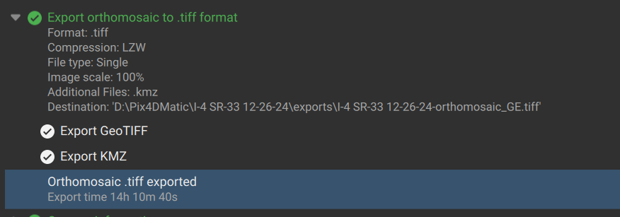
Hi all, I’m happy to announce that you can now export the orthomosaic in KML or KMZ. Download PIX4Dmatic’s new preview version 1.72 here and let us know what you think! Cheers
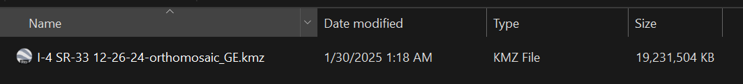
Tried this yesterday. Took 14hr and trying to load into Google Earth I get a “No results - empty KML file error”. Resulted in a 19GB KMZ vs 21.7 GB for the TIFF. Also, I couldn’t figure out how to generate just the KML/KMZ and not regenerate the TIFF which I already have.
Think I’ll pass on this “feature”

Hello!
I believe that there might be a maximum size of a KML or KMZ that can be imported to Google Earth. This page by Google Support provides some details, it mentions that
unzipped KML and KMZ files can be up to 1GB
and it looks like that the same limitations apply to the desktop version of the product.
One thing you can try to do is to export the orthomosaic at 25% image scale to reduce the size of the file, if the result is still larger than 1GB then another option is to generate lower resolution DSM and orhtomosaic (by setting “Custom” resolution for DSM) and re-export them to KML/KMZ.
Hope it helps.
Kind regards,
Alexey
Thanks. I guess I’ll just have to play with the various scale settings to see what impact they have on the outputs.