I have been conducting very detailed notes on testing for 2 days and have not been able to get a single successful map processed. The stitching issues very from hexagon patterns to wave patterns. I started testing at 400ft because i figured it would be the easiest altitude to generate a map at. i started off with 400ft at 75% overlap at multiple speeds and had no success, I moved on to try 400ft at 80% overlap in different speeds and still had no success. One map in each overlap came close to good but not great or perfect. I attached a file of my testing sheet and screen shots of the stitching issues i am experiencing. There are three different maps i added to this post, they go from worst to best but none are perfect. Below is my workflow and all the other necessary information is in my testing sheet. Someone please help. I purchased the Micasense red edge MX after a horrible experience with slantrange and sentera. I am trying to make the transition over from Drone Deploy to pix4D but cannot do so until i have consistent data. I have 3 days left on my free trial and can not commit to the annual purchase if i cant get a successful map.
- Set up drone
- Automatic QR code capture
- fly mission
- process data with reflectance panel
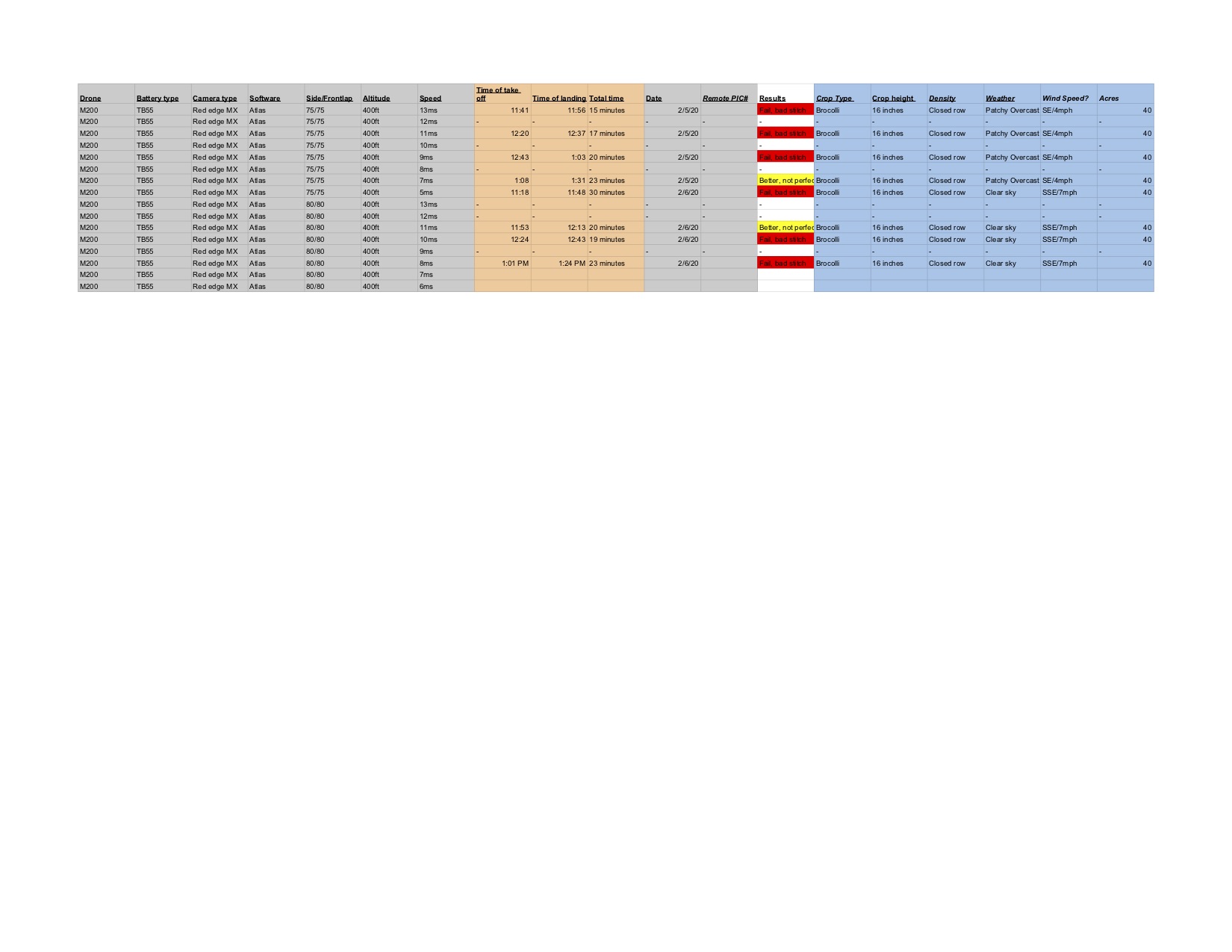
RE MX stitch testing sheet - Sheet1|647x500
Hi @jerimiah, Can you please write us a support ticket? We will look into the details and try to troubleshoot. When computing the 3D point cloud, the height might not well be estimated mostly for crops or trees. This results in height differences for points that are supposed to be at the same height. The orthomosaic is generated using this 3D point of cloud. When the height is not well estimated, it results in distortion artifacts. Increasing the overlap helps, for crops, I have always seen good results with at least 85% overlap, it is good to consistent because early stages of crops are easy in photogrammetry but when the crops grow dense, the soil or any other feature gets hidden and it becomes hard to extarct keypoints. Thus it is always good to go with 85% or more. 400 ft seems to be a good height. Also nadir images work better for crops. Other things would be clear sky, overcast may create these blotches. We would need your images and quality report to troubleshoot. Please reach out to us (with link to raw images and quality reports), we will also extend your trail so that you can test more. I would say the first two maps look wavy and bad, the last one looks good.
Hello,
I created a support ticket and I will test again with the information you have given me. I have been in contact with Micasens and they claim i am already well within the parameters of settings to create a successful map but i will give the 85%overlap a try. I will need my trial to be extended for further testing, Is it possible to Have it activated now. im still running test on processing but my trial is already over.
Hi Jermiah,
I will respond to your support request directly and update here after we complete troubleshooting.


