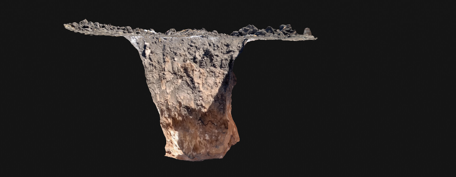
hello, I share with you the modeling of an open pit that was carried out to study the soil stratigraphy as part of the soil mechanics study for a new construction (greenhouses). This type of soil is classified as highly expansive clays and they have the characteristic that when their moisture content increases they expand and when they decrease they contract, it is the main type of soil that exists where I reside (Querétaro, Mexico), that is why it is It is important to study this soil to issue the correct recommendations for the foundations of buildings. The first layer of the mentioned high expansive clay (SUCS: CH) can be seen, the lower layer is a sandy silt. PIX4D CATCH was used for the modeling of the stratigraphy and PIX4D CLOUD ADVANCED to process and have the general survey of the site and the commented modeling online on the same platform and with the same link. In this way, we innovate in the part of the pre-construction studies, we incorporate geotechnics (soil and rock mechanics) to the Construction 4.0 part and we process them BIM. If the client wishes, we continue with the monitoring of the work on the same platform and with the same link and in addition to having the global monitoring we can model the structures or construction details with pix4d catch, that is the added value.
Surveying a Waterline install on The Bay Project Sarasota Florida. Trying out Pix4d catch to see of we can utilize this in our everyday surveying projects.
Check out the wrench in the bottom of the excavation.
3D model for measuring snow depth.
I produce models for machine control systems of snow groomers. Exact snowdepth is calculated in real time during snow grooming. This makes the logistics of producing and moving snow a lot easier and cuts costs greatly.
I maintain a model covering a mountain ski resort, whenever there has been earthworks somewhere in the area then the model needs an update for accurate snow depth readings during winter. My challenge entry is a small model of part of a Ski slope that had earthworks done recently.
A perfect digitized 3d model to Catch each minute detail to make the city smarter with smarter choice/decision.
The project is about the digitalization of existing corridors in each detail (@Jodhpur, India). But we can think more …
urban planning (improves the quality of life)
flood modeling (reduce risk)
Intelligent surveillance (Improves public safety)
Intelligent traffic management (because building the things not a solution anymore),
I hope, will capture more and more for a better tomorrow .
Thanks, Pix4d team for making the community active with these challenges . It’s thought-provoking sometimes
Hey Community,
I‘m a absolutely newby in photogrammetry. I owned a little drone and i realized very soon that i can do more things as just make cool videoclips or photos. So i searched on internet what i can do with the drone. I came to photogrammetry. A second hobby i have is exploring abandoned sites.
This is my first try to scan one of this sites.
This phosphate quarry is located in the Thies Region (Senegal). It is no longer exploited and this mapping mission aims to make an inventory of the site in order to rehabilitate or redevelop it.
This 03D mapping allows to determine the facies by direct observation, to detect geological accidents, or to make the natural sounding of the layers, and many other applications.
For a little more detail, I’ve included a screenshot that shows some of the measurements I looked at in the model.
The form boards should be about 5.75" apart, so the two measurements of 6" and 5.7" are in line with what I’d expect.
I don’t have the opportunity share any of my construction projects at this time. So I made this for fun and for training purposes
The one route I usually jog is a short railway that was made to demonstrate how lime and iron were extracted a long time ago. The train section is only for demonstration and the trains do not run more than a couple of times a year for children to experience. Along the railway, therefore, some stations have been made for fun. At one station there is an underwater bomb and an underwater missile (I am 99,99% sure they are safe!). I have no idea why they are there or how they got there. It was still a nice challenge for terrestrial photogrammetry midway through tonight’s jog.
I set Pix4Dcatch to take pictures every 50 cm with 90% overlap and ended up with approx. 400 images (I did some extra rounds for safety). It was demanding to avoid including background elements outside the area of interest when doing it from the ground, but this was an area that was not easily accessible to drones either - a nice challenge. It’s still the little platform with a house and two bombs that I have aimed at here!
This is our project of an active recreation park for children and adolescents.
The park is almost finished.
There are a few final touches left.
In particular, small fences around the perimeter of the main objects.
Hey boys and girls! How are you!
A very funny situation…
I haven’t visited pix4d for a long time.
And yesterday I went to the site and saw a message about the challenge.
Right now we are doing a lighting project for the fountain!
And for visualization, we are building a fountain model!
Now you can take a look at this composition!
(the lighting project itself is not available under the link, since it cannot be done on the cloud)))
So this is another capture I’ve done (and a checky additional late entry) Captured with pix4DCatch using an iPhone 12pro and processed using pix4D Cloud.
I’d like to use Pix4D advance to re-capture, reprocess or prepare this scan (if that can even be done with Pix4DCloud Advanced??)
It’s a scan of the College MUT (Mobile Unit of Technology) with modified interior option.
I would like to capture some different possible layouts for how the van can be used with the range of kit in it with the intention of refitting and making the van more functional - kit includes scanning and survaying equipment, robotic arms, drones, AR/VR and digital fabrication capabilities.
and then of course use pix4D with some drone and phone Imagery recreate some places of interest around Ireland over the next few months !!
Challenge Post:
Testing Pix4Dcatch with iPhone X to see of we can use this tool in our restoration job of a 100 year old lobby of a theater in Harlem area, Manhattan NY. The looby will be use as an main entrance and lobby of new hotel. That includes new terrazzo floor replica with mosaic insertions, Botticino marble walls.
This is the first time I have used this program. I understand that there are many power users here.
So don’t judge too harshly. Anyway, I wanted to participate.
Construction work has not been completed yet and the model must meet the conditions of the competition.
And the story is simple - we change the pipes of one of the streets.
As forest scientists, we try to use drone or cell phone imagery to capture wood piles and find ways to measure their volume. This can save a lot of manual work. However, there are still many challenges to master. Here is a first attempt on this way. The 3D images/models are also very popular in teaching.
These cookies are necessary for the website to function and cannot be switched off in our systems.
They are usually only set in response to actions made by you which amount to a request for services, such as setting your privacy preferences,
logging in, or filling in forms. These cookies do not store any personally identifiable information.
These cookies allow us to count visits and traffic sources so we can measure and improve the performance of our site.
They help us to know which pages are the most and least popular and see how visitors move around the site.
All information these cookies collect is aggregated and therefore anonymous.
If you do not allow these cookies we will not know when you have visited our site, and will not be able to monitor its performance.
These cookies may be set through our site by our advertising partner (Google).
They may be used by Google to build a profile of your interests and show you relevant adverts on other sites.
They do not directly store personal information but are based on uniquely identifying your browser and internet device.
If you do not allow these cookies, you will experience less targeted advertising.