Hi, I’m trying to process some aerial imagery data in Pix4DMapper and export the resulting DSM and RGB data (transparent_mosaic_group1.tif). I’ve done this successfully for several other projects on the same computer. However, I’m currently getting a weird error that I can’t explain.
Can anyone help me understand what’s causing this error message? The area I’m mapping is small. There are only 18 drone pictures in the project. The processing goes smoothly for a while. Then, I start getting a mixture of yellow, red, and green output lines.
I’ve copied the full error message below:
[Warning]: No initial frame
[Error]: no blocks computed
[Error]: No calibrated cameras.
[Processing]: Substep Camera calibration finished.
[Processing]: Substep Report generation started.
[Processing]: Read keypoints.
[Warning]: Failed to read uncertainty data from /Users/me/Desktop/Madera Canyon drone photogram pics/mc/1_initial/project_data/result_uncertainties_absolute_full_1.p4b
[Warning]: Failed to read uncertainty data from /Users/me/Desktop/Madera Canyon drone photogram pics/mc/1_initial/project_data/result_uncertainties_relative_full_1.p4b
[Error]: Error e0046: Processing failed. No calibrated cameras.
[Processing]: Substep Report generation finished.
[Processing]: ProjectLoaded
[Error]: Error e0104: Network Error - code: 400, Network Reply: {“license_string”:[“This field is required.”],“event_name”:[“This field is required.”]}
[Error]: Error e0104: Network Error - code: 400, Network Reply:
Hi @Daniele_Lecci , I’ve attached a screenshot of the quality report. Let me know what you think! None of the pictures of blurry and I haven’t ever used GCPs in the past, but have never encountered this problem.
Thank you for your reply.
18 images are really few. Is there enough overlap between them? Could you send us a couple of these images so we can check the overlap?
Hi @Daniele_Lecci , I agree that 18 images isn’t ideal, but in the quality report it says that the ‘images’ and ‘matching’ sections got green check marks indicating there were enough key points and matches per image. I’d think those parts of the quality report would have failed if the small photo number was the problem. Although, in the ‘dataset’ part of the report, I see that too few images were able to be calibrated. Is there some way to override whatever the error is so I can still generate the RGB and DSM and just accept that there’s a higher level of error/inaccuracy in the data generated?
Thank you for your reply and the two pictures.
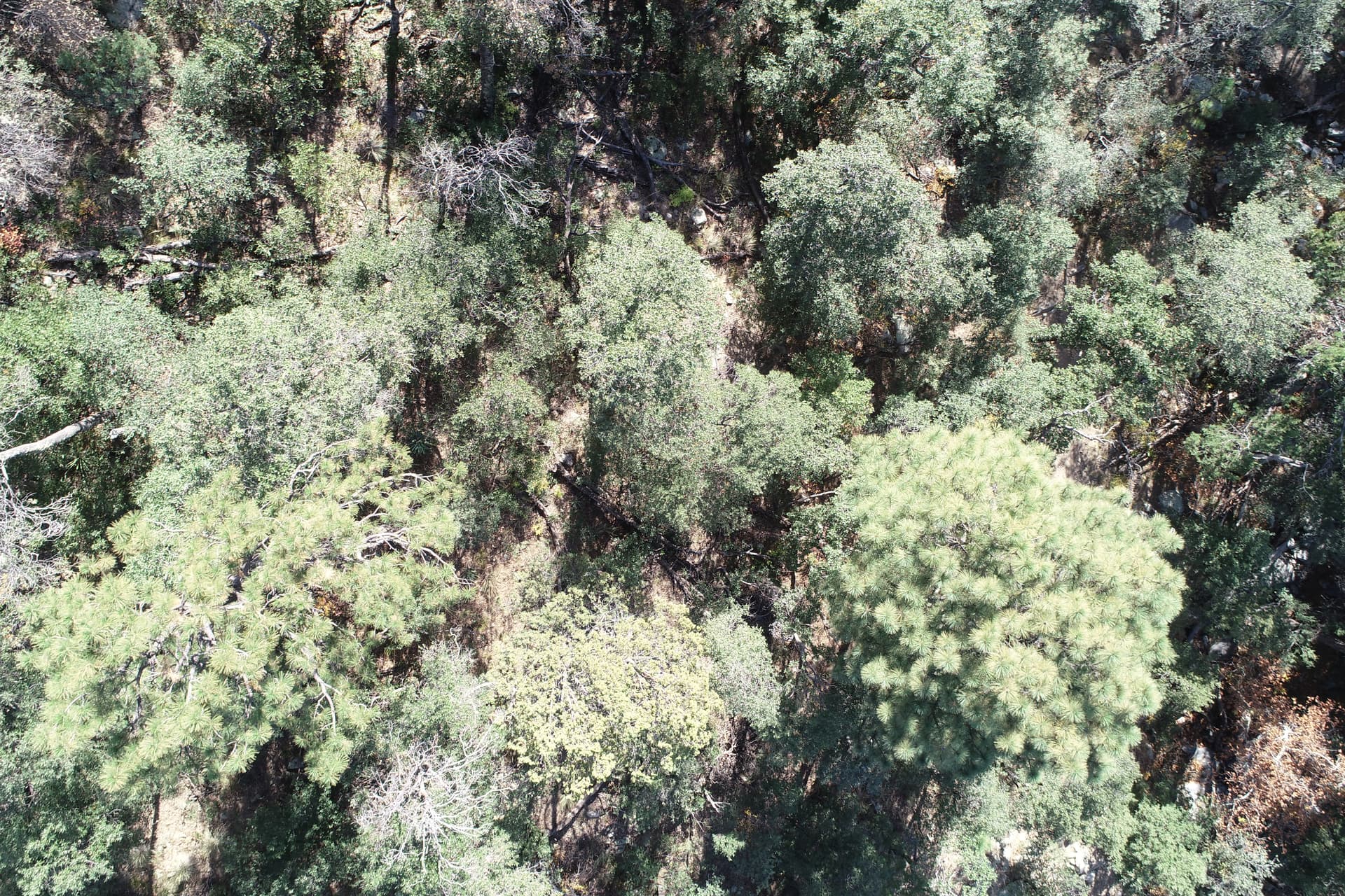
The diagram may show a good overlap as it takes into account theoretical values, but the reality can be different according to image content. High vegetation while flying so low can be challenging. The overlap might be good on the ground but bad on the vegetation.
I’m now looking at the two images, and I can’t find any match. Are these images consecutive? Would it be possible for you to share all 18 images?
Hi @Daniele_Lecci . Yes, these photos were unfortunately consecutive. This site is pretty densely vegetated, but I’m still hoping to find a way to process the project. I’ll gladly share all 18 of the photos with you. Would it be easier to email them? If I upload them here the website makes me attach them one at a time for some reason… so I’d need to reply 18 times below to share all the photos with you. Let me know what’s easiest. Thanks!
Hi @Daniele_Lecci , I just uploaded all the images to that folder. Please let me know if you have any issues accessing them. And thank you for the help!! I really appreciate it!! I’m still really hoping there is a way I can generate the DSM and transparent_mosaic_group.tif file, even if there output has lower accuracy or higher error because of the vegetation. This site is very hard to reach and doesn’t have any cell service. There were several issues contributing to making this a particularly hard site to map. And furthermore, I don’t think I’m going to be able to go back to this location to collect the drone data again if we can’t get the project to process, so I’m really hoping we can find a solution of some sort. Thanks again!
I visually overlap the images DJI_0599.JPG, DJI_0600.JPG, and DJI_0601.JPG and the frontal overlap is about 50 to 60% (image below).
You will need to increase the overlap between the images to at least 85% frontal overlap and 70% side overlap.
Thanks for the help. This makes sense. I’ll try and get out there and re-map this site. One last question…
I use Pix4dCapture to map the projects and collect the aerial imagery data with my drone. For this location, I set a very high drone height for the project because I knew I’d need to launch the drone from the base of a canyon that is going up a mountain. So the drone would be flying up the canyon going up the mountain, and so the actual height of the drone relative to the landscape is a lot less than whatever I set the drone height when I’m setting up the project. I think that the project didn’t capture enough photos because the software picked the number of photos based on the height set, not the actual height of the drone relative to the vegetation. Does that make sense?
Do you know how I could override that in pix4d capture to increase the overlap?
Hi Lauren,
There is no option in PIX4Dcapture to override changes in elevation. I would suggest looking at some other flight applications that use a terrain following feature. This will help in your image acquisition. You can check the article below for recommendations.
Thank you. That information is helpful. The website you linked makes it clear that Pix4Dcapture isn’t good for complex terrains, but I didn’t see where it says what flying application should be used in those circumstances. Would you recommend pix4Dcatch for a site with varying terrain?
These cookies are necessary for the website to function and cannot be switched off in our systems.
They are usually only set in response to actions made by you which amount to a request for services, such as setting your privacy preferences,
logging in, or filling in forms. These cookies do not store any personally identifiable information.
These cookies allow us to count visits and traffic sources so we can measure and improve the performance of our site.
They help us to know which pages are the most and least popular and see how visitors move around the site.
All information these cookies collect is aggregated and therefore anonymous.
If you do not allow these cookies we will not know when you have visited our site, and will not be able to monitor its performance.
These cookies may be set through our site by our advertising partner (Google).
They may be used by Google to build a profile of your interests and show you relevant adverts on other sites.
They do not directly store personal information but are based on uniquely identifying your browser and internet device.
If you do not allow these cookies, you will experience less targeted advertising.