in mapper I can import a csv with arbitrary image coordinates (x,y,z). I can’t seem to find a similar solution within matic. I can have an output crs in arbitrary, but I can’t import my image locations as arbitrary x,y,z. am I missing something? is this a feature that will be supported soon?
Hi Kevin,
The feature of importing image geolocation and orientation coordinates is supported.
Could this be what you are looking for? Image geolocation and orientation import format - PIX4Dmatic
This feature has been available since v1.10.0. For your reference: Technical release notes - PIX4Dmatic
The import of image geolocation and orientation is available after the images are successfully imported by using: File - Import image geolocations and orientations….
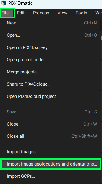
Once you click Import image geolocations and orientations…. You will see the Image geolocation & orientations window open.

Let us know if you still have questions about this feature!
Best regards,
Rosana (she/her)
@Kevin_Dawson we don’t support the import of geolocations of images in an arbitrary coordinate system as of now. That said, we plan to add the support of this.
I assume you do this because you want to have your geotags in a specific coordinate system. Can you tell me which one?
I’m wondering whether this alternative would work too:
- Import images, the project CRS gets derived from the image geotags
- Set the GCP CRS (which indirectly modifies the project CRS), even if there are no GCPs
- All results will be processed in the selected CRS and the transformation of the geotags will be done within PIX4Dmatic.
That said, this only works if the CRS is supported, I guess it is not? But just in case it’s good to check. If it’s not supported, we can look into supporting it too (we’ll still work on the import of arbitrary CRS geotags for images).
Thanks!
thanks for the feedback, I primarily use pix4d for surveying in mining applications. most of the mines have a local coordinate system that is not known, or even based on a known coordinate system. I can manually add the ground control points, but I have to use ground control points to do it. I have used mapper very heavily over the years and previously I would just bring in the image locations in the local x,y,z, coordinates via the image properties dialog as a csv file.
I’ll give it a try with your work around and let you know how it goes.
I’m glad to hear there are plans to support this features in the future. I would really love to have a image properties dialog box similar to mapper, but with geoid support.
@Kevin_Dawson if you’re working more than once on the same site, it may be worth to setup a Site localization file, that way you create the file once and then you only need to use that instead of modifying your geotags. More about this here: