Hi. If we can import diferent point clouds (las files) to Survey, and individualy calculate volumes in each point cloud, can’t you make an option for calculation directly the diference between the 2 volumes, and put it in a report?
Thank you for the feedback, @Jorge_Santos, don’t forget to “vote” for your request ![]()
This function is much needed. Currently I have to use third party software such as 3Dsurvey, Civil or TBC. This can also be done in QGIS, but using DSM.
It would be super if it was possible to do an earthwork balance between the two models right away in Pix4Dsurvey.
Hi @mwywial, and welcome to the Pix4D Community ![]() .
.
Thank you for your feedback and for sharing your current workflow and what would be your desired workflow.
I would much welcome this feature as well
Welcome to the Pix4D community ![]() .
.
Can you please share with us your use case, your current workflow, and a description about this would be beneficial for you?
Cheers.
Hi. My current workflow is to export the 2 different point clouds from Pix4dSurvey, and in Civil 3D calculate the 2 surfaces from the point clouds and make my reports. It was great if we could have a simple tool to compare both point clouds in Pix4dSurvey (choose the area of interess in the point clouds also)
Thank you for your feedback, @Jorge_Santos
If it is not possible to calculate the volume directly from the point cloud, then perhaps it would be simpler to allow users to make two TIN models from two point clouds and on the TIN calculate the differences in volumes, what do you think about this?
Hello!
Is the Pix4Dsurvey development team working on adding this functionality? Is there a chance to add this functionality within the next year?
I would also like an update on this functionality!
This is a much needed function for earthworks and something I’ve been looking into consistently for the last couple months. As previously mentioned by others, there are other software options out there that can do this, but the added cost makes it extremely difficult to rationalize to my supervisor. Yet, I keep getting asked for this information. Are there any updates on this coming to PIX4D Survey?
up.
To calculate volume between two point clouds, align them create meshes or surfaces then compute the volume difference between the top and bottom layers apps like CloudCompare or MeshLab can this help.
I also think this would be a core part of Survey software. I am fortunate to have Topcon Survey to continue my workflow currently, but there should be this overlap.
I would think that as it stands in PIX4D Survey, there would be limited usefullness of volumes derrived from only one surface at one point in time.
I just saw this in the release notes:
1.85.0
New Capabilities
- Added the option to import a base surface from a LandXML file for volume computation
But can’t find how to implement. I brought the surface in through File→Import, and it shows as a new layer. But how do I choose it for the base surface for the volume calc?
Hi @scavendish
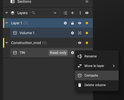
The imported LandXML is the base surface to calculate the volume. Once the LandXML is imported into PIX4Dsurvey, it creates a new layer with the file, then you can compute the volume using the “Compute” button in the toolbar or doing clicking on Compute inside the geometry actions button
Clicking Compute on the imported surface just gives me a “Not enough memory for volume computation” error. I have 64GB.
Hello,
Thank you for reporting this issue. Could you try importing a smaller surface and see if the volume processing works for it?
Kind regards,
Alexey
