Hi Pix4D. I am using Pix4DMapper to stitch thermal imagery from a FLIR Vue Pro R camera. The temperature values in the raw R-jpeg files have one decimal point, but the output TIFF from Pix4D only has whole temperature values (i.e. no decimal point). Is there a way to output the TIFF with decimal point pixel values as well? I can make this data available to you. Thanks so much
Hi Natalie, Pix4DMapper should generate a floating tif map. Can you give us a screenshot of the min, max values in the index calculator? You can share the data with us as well.
Hi, thank you for getting back to me so quickly.
I have to amend my query slightly based on the results I’ve obtained today.
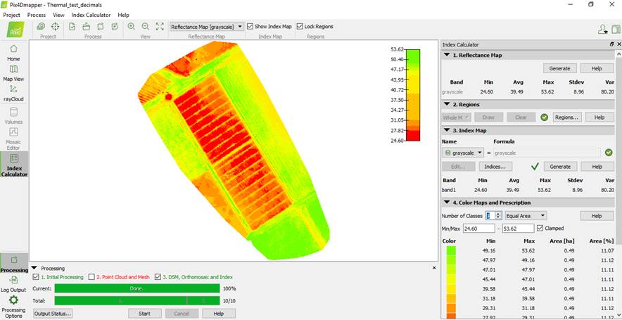
The index calculator screenshot is shown below. It seems as though the pixel values have two decimal points now that I have “restitched”
the images with the newest Pix4D version. The whole decimal values were obtained using a previous version of Pix4D about a year ago, so maybe it was a function of the software at the time?
We are using these TIFFs in ArcGIS to try and separate hot/shaded soil from green leaf pixels to obtain more accurate estimates of canopy
temperature.
To do this, we are using the “extract by attribute” function, which allows us to group similar pixels based on training sites (i.e. polygons
drawn around green leaves, shaded soil and bare hot soil).
What we’re finding is that the “extract by attribute” function works well when the pixel values are whole, but now that we have two decimal
places, it is no longer working to group pixels. This is supervised classification.
Is there a way to do something similar using Pix4D? In the index calculator screenshot below, it allows us to create classes, but this
is unsupervised classification.
Alternatively, do we have control over the number of decimals in the output TIFF in any of the Pix4D processing steps?
Hi Natalie, You are right, we do unsupervised classification for the zonation map (clustering). Pix4D has no such function of rounding off to a specific decimal place. You can use QGIS or ArcGIS for the same: Rounding pixel values of raster in QGIS - Geographic Information Systems Stack Exchange. I think ArcGIS has round_up and round_down function which you can use. Hope it helps.