NDVI with Sequoia camera

For normal sun angle correction (not the DLS IMU one), these tags need to be there (screenshot below). This is not only for target images but for all the images because these values are all for light sensor correction (sun irradiance, sun angle, etc). The DLS writes these tags for each image so that radiometric correction is performed on each image. With the radiometric target, radiometric correction is performed on the whole map.

You can try once with camera only and radiometric target images. Process step 3 after that.

My project was done with “Camera and Sun Irradiance”, what other option should I test ?

Use camera only now. The target images will already be used. If the target images are being used, you will have a green check mark beside calibration (like you have now).

image

I can’t click “Start”. I can click start only if I select the steps 1 + 2 + 3, so I try without GCP, and I will see tomorrow, thank you for help.

It’s not better, it’s worse !

I would say its very similar (so in short this did not solve our issue). Can you send me the full dataset if that’s okay with you? I can give it a try to see what is causing these artifacts. If you have the quality report, that would help as well

Natacha,

I have been having the same problem with my Parrot Sequoi, and always with Green band,

Have used Parrot panel calilbration following Pix4D choose best calibration image (Parrot Sequoia - Choose best calibration image) and doing processing .

An interesting case I have here. Same area, same flight, almost same hour (10:30 h Rio de Janeiro - Brazil), and have one good result with consistency indes result and other a complete worng.

I would like to understand what is happening.

Thank´s

@alealbuquerque If you have valid support and upgrade, it would be great if you can write us a personal support request and share the images with us. It seems like there are shadows and bright spots. If not you can share with a google drive/one drive link here.

@momtanu.chakraborty, thank´s for reply. I have not valid support.
It seems like there are shadows and bright spots No, the sky was clear. A perfect ble sky.
How I told, I´ve been having this issue only in Parrot Sequoia green chanel. I have 3 flight in same area.

. How you can see, flight 05-12-2020 green band has processed without problem. Also have other 2 (05 22 and 27 ,2020). These had problem in green chanel.

Here are links for download of 0512 and 0522 flights. Maybe you can process and tell me what´s wrong with data.
https://1drv.ms/u/s!AnXDXBNFKpdCswn6kmrHpLEiBITN?e=w2hzk1
https://1drv.ms/u/s!AnXDXBNFKpdCswgOyWQQ7-qElABm?e=M9bVaq

Thank´s

Hi,
I’m sorry but I don’t have the answer to give you because I didn’t manage to remove the artifacts with my data with PIX4Dmapper.
I’m going to test another PIX4D tool to see if the artifacts appear with it.
Natacha

1 Like

@alealbuquerque I had another user data with a similar issue like yours and when I analyzed I found out that there were sparse clouds. It is not recommended to fly when the sky is partly cloudy or there are sparse/popcorn clouds. If there are sparse clouds, the DLS sensor is not able to take accurate readings. The screenshot may explain why the DLS sensor is not able to account for the clouds.

Can you try processing without the DLS sensor data (camera only) and the radiometric targets? I couldn’t access your data as I don’t have a Microsoft account :frowning:

@Natacha’s issue seems to be something different and I couldn’t figure out the cause of the stripes. She is testing Pix4DFields and after she is done with that, we will do more troubleshooting.

@alealbuquerque, I have tried with your green images with 3 softwares.
For you, it seems to be the sun the problem. Try PIX4Dfield with your data, it’s free one month to test.

.
I can’t help more because I don’t know this software. I have just tested with my data.

With PIX4Dfields, the artefacts on the RGB mosaic are less visible :

For the reflectance maps, there are still here :


On the green @alealbuquerque images, there is not artefact…


even if some images are very exposed
Capture_alealbuquerque2

Natacha

1 Like

Thank you @Natacha. Great work on all the testing

Dear @momtanu.chakraborty,

You told have other user with same issue. I can tell you sky was perfect blue, any cloud in all days. We have now incredible fall days now in Rio de Janeiro. You can see this video (Três Quedas Final e Pouso - YouTube). Is first flight last line and going to land. In time 14 seconds you can see study area and sky… Is it not possible some sparse cloud do some issue only in green band? And others?
I will try to process only camera parameters and radiometric targets. It is not necessary Microsoft acocunt to dowload data.

Dear @Natacha, you did tests with my green band with 3 softwares. I can see that Pix4DMapper and Pix4Dfield have different results of same data. It sound strangers because with same data both softwares (Mapper and Field) should be same result.

In your data, artefacts from RGB camera have different results too. I can tell you I usually do flight with Phantom 4 Pro in same area, becuse RGB camera from Parrot Sequoia does not have good results. Camera is rolling shutter and Phantom 4 pro, like multispectral parrot sequoia are global shutter.

Yes, I have good mosaic even with bad reflectance data. But image mosaic from green, red , rededge and nir is not my idea when you can work with reflectance.

Thank´s
Alexandre

@alealbuquerqueIt It asks me to sign in.

It might be an issue with the DLS sensor as well. Pix4D reads all the radiometric correction tags from the image EXIF data, so if something is wrong there, that will be reflected in the result.

@Natacha Can you say what was the sky condition you chose in Pix4DFields? This is because the sun angle correction is done differently in case clear sky or overcast is selected. Both the softwares have same radiometric module but the general algorithm is different.

I am sure you will get good results (without the artifacts) when you use camera only correction and the radiometric panels/targets. Orthomosaic is radiometrically corrected which is why you are not seeing any artifacts there, also orthomosiac is color balanced. If something was wrong with the DLS sensor, weather conditions it will be reflected in the reflectance maps.

And you are right, sequoia RGB camera mainly should be used for scouting and with a lot of care due to the rolling shutter. Flying high and slow usually helps.

@alealbuquerqueIt

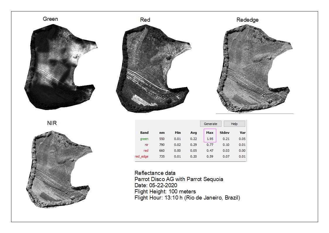
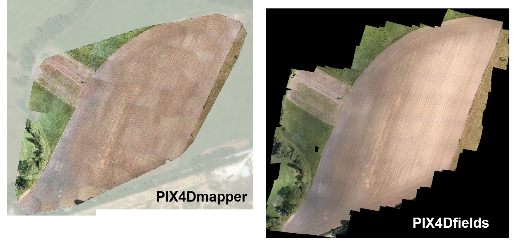
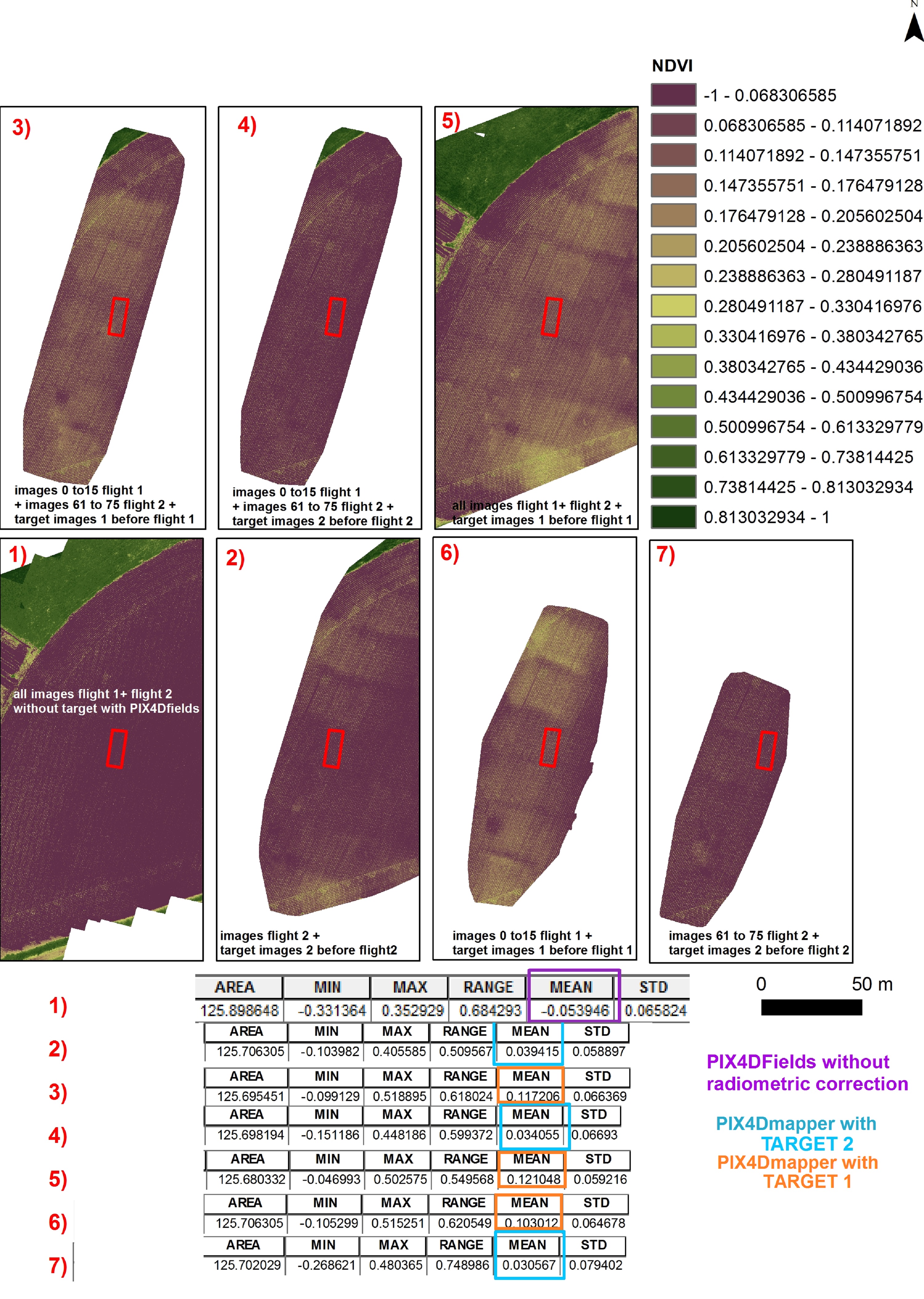
“you did tests with my green band with 3 softwares. I can see that Pix4DMapper and Pix4Dfield have different results of same data. It sound strangers because with same data both softwares (Mapper and Field) should be same result.”

Have you tried with both ?

“In your data, artefacts from RGB camera have different results too. I can tell you I usually do flight with Phantom 4 Pro in same area, becuse RGB camera from Parrot Sequoia does not have good results. Camera is rolling shutter and Phantom 4 pro, like multispectral parrot sequoia are global shutter.”

I know, we have acquired a Phantom 4 pro for some time but in these flights here, I had only RGB and Multispectral Sequoia cameras on a 3DR solo.

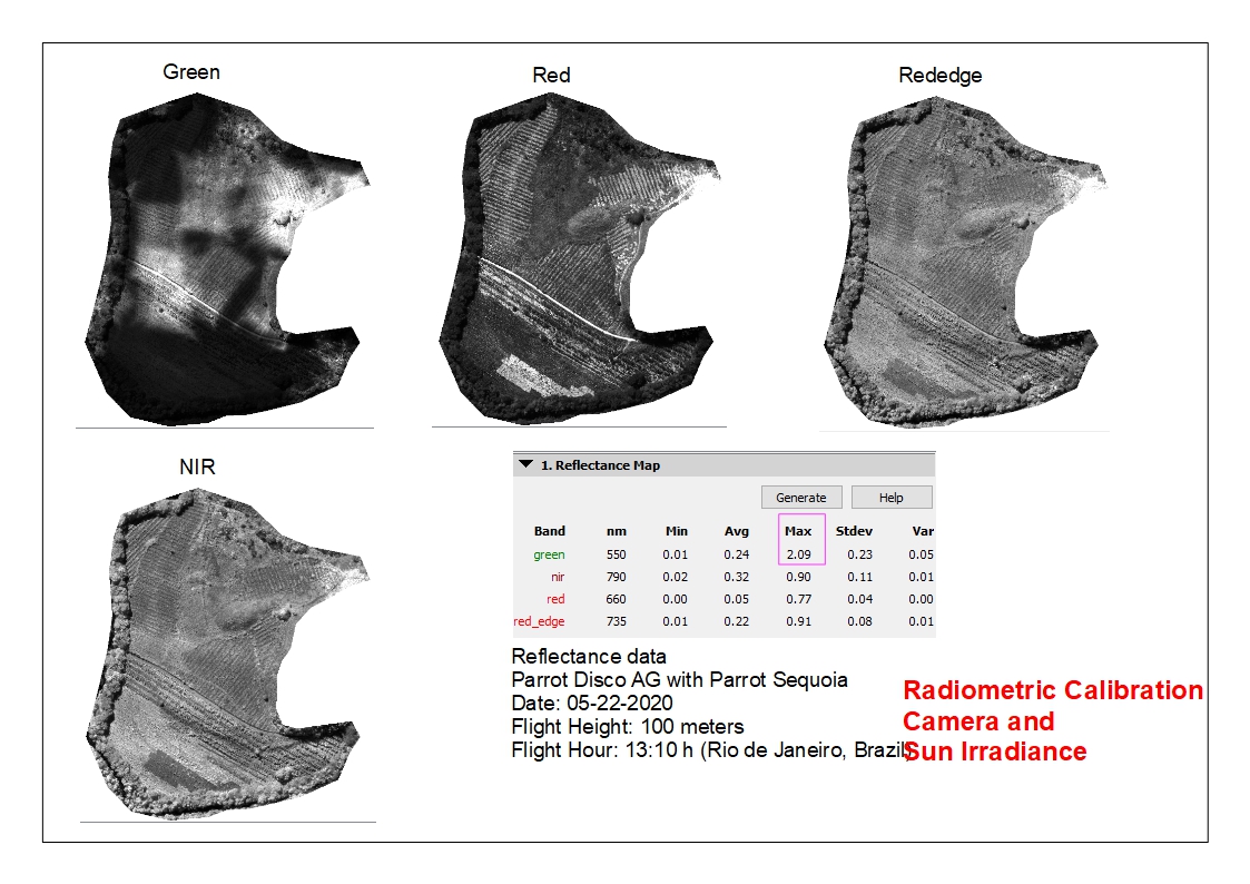
“Yes, I have good mosaic even with bad reflectance data. But image mosaic from green, red , rededge and nir is not my idea when you can work with reflectance.”

It was for help, with pleasure to have tested for you, if your reflectance map has a problem, your data will have also a problem, no ?

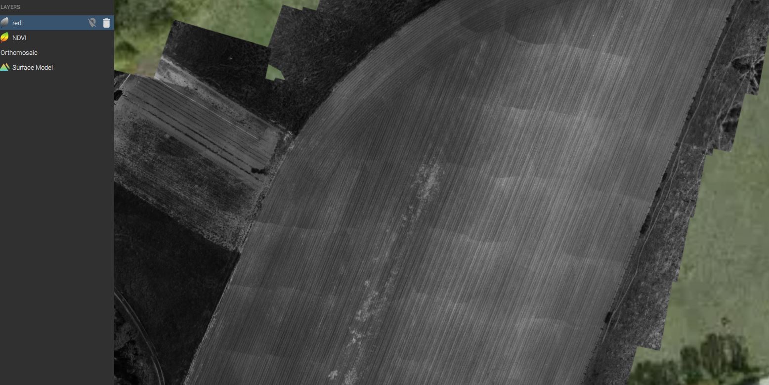
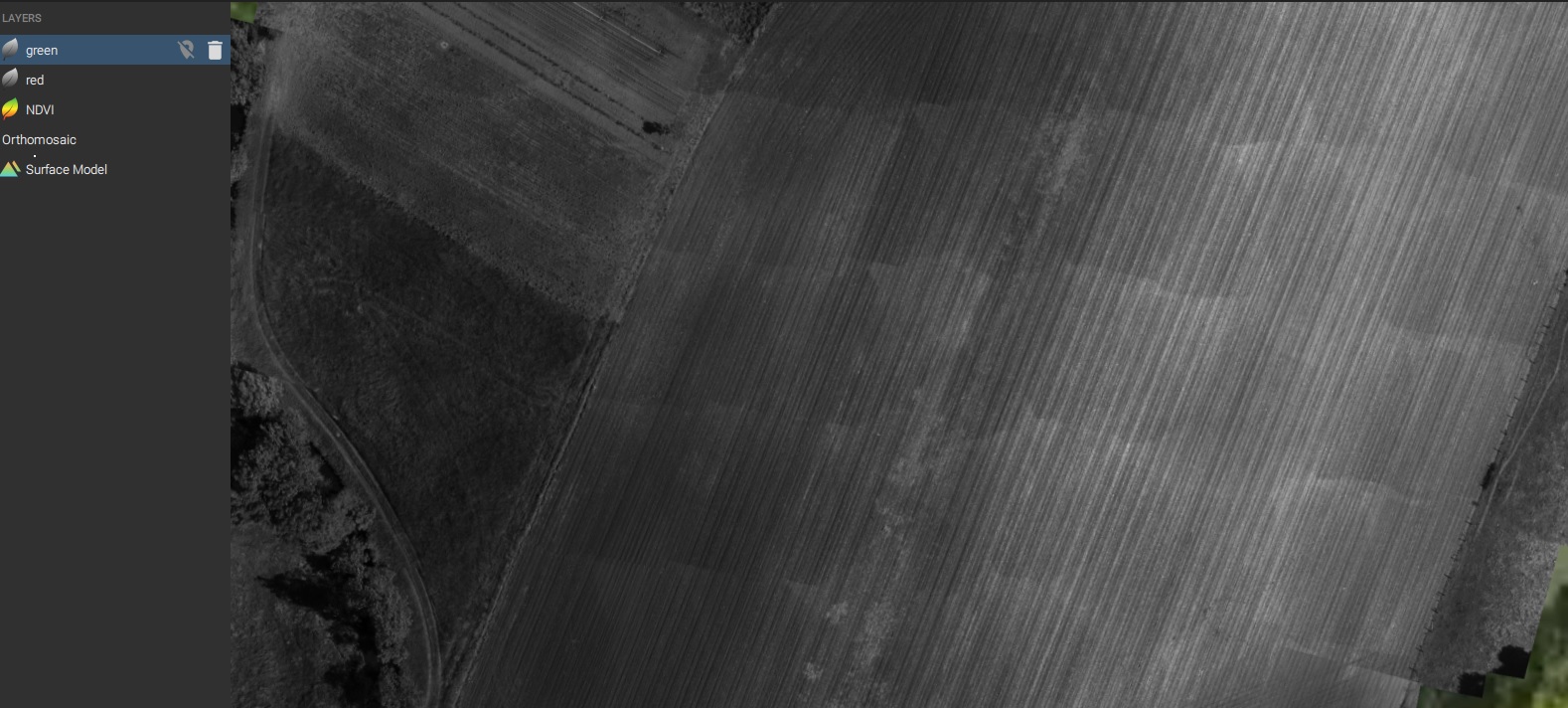
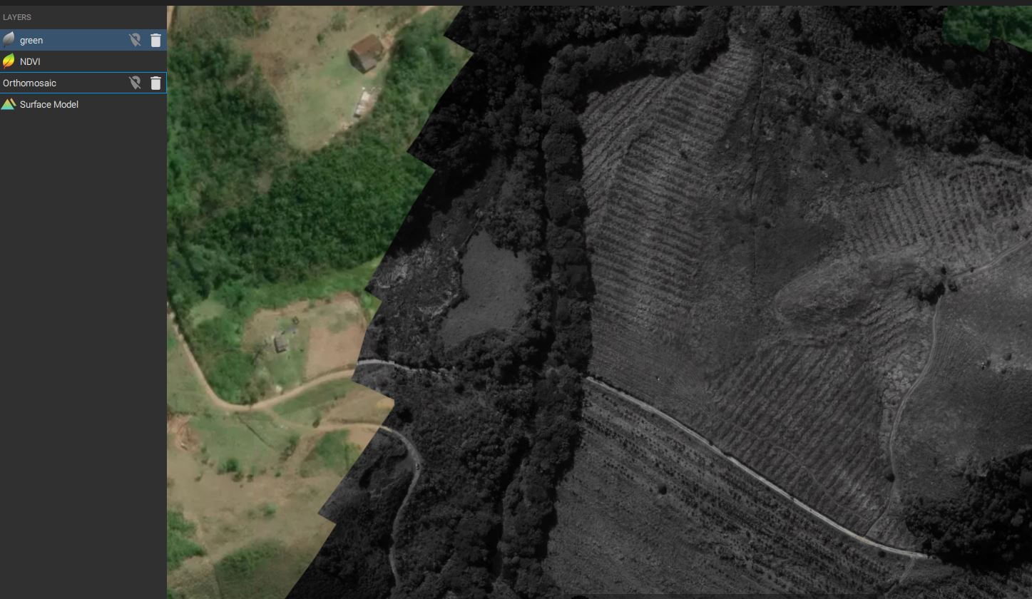
Anyway, my problems are the artefacts on the reflectance maps.

Dear @momtanu.chakraborty,

Thank you for trying to find a solution. Indeed, I was asked for an account to download the data.
In the alealbuquerque images, it’s possible to select the weather conditions during capture. For him, I have chosen “clear sky”. For my data, I can’t select this parameters. This should explain why the correction does not apply. How can force this parameter ?

Thank you
Natacha

Natacha, This is because you do not have sun angle tags. For sequoia, only ebee has it. I think you might be using bluegrass. @Natcha what happens for your dataset when you disable radiometric correction? Do you still get the stripes?

Hi @momtanu.chakraborty

For the LCI and MCARI, there are some stripes but for NDVI, red and green reflectance maps, it seems good.

So I can’t correct the data and this software doesn’t accept GCP.

And the NDVI is different without radiometric correction with the target 2.

See attached the results for the NDVI.

So what can I do to have good NDVI values and reflectance maps without stripes and include GCPs in the project ?

Now, we have a Phantom 4 pro + Sequoia, I can’t buy Bluegrass.

Thanks
Natacha

Hi @Natacha and @momtanu.chakraborty,

I did other two process with my data. Only radiometric camera correction and radiometric camera correction + sun irradiance sensor, using data from 05-22-2020.

Well, it is possible see that radiometric calibration using camera only had good results. Radiometric calibration on camera and sun irradiance do not have good results.

I will try to do other flight same area to test.

Thank´s for all