I used Pix4D mapper for uploading drone images taken from a bridge. While all the images look correct in the dataset, images in the software look inverted after the “Initial Analysis.” Even after the analysis, the 3D model looks distorted with gaps in the 3D model.
Can someone please help me how to solve this issue.
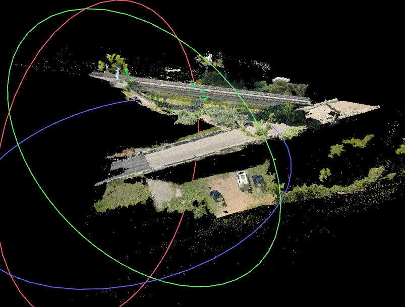
Do we have any options for back face culling using Pix4D ? If so, can you please provide me with the required guidance and documentation? This is to create good 3D model of bridge deck on both sides.
Hello. I am planning to try with Pix4D matic. However, I already have pix4D mapper license. How can I convert my license to that software. However, Can I use the pix4D mapper license to login to higher versions? Currently I am using 4.8.4. can I use this license credentials to use 4.10.0 or 4.9.0?
To log in to the latest version available to your license, please follow this procedure:
Ensure you log in with the account used to access PIX4Dmapper and select the organization that holds the license. If only version 4.8.4 appears for download, then you cannot use your license with higher versions.
Regarding the conversion of the PIX4Dmapper license to PIX4Dmatic, please reach out directly to our sales team here:
Make sure to explain your situation and needs, but I also suggest starting with a free 15-day trial.
These cookies are necessary for the website to function and cannot be switched off in our systems.
They are usually only set in response to actions made by you which amount to a request for services, such as setting your privacy preferences,
logging in, or filling in forms. These cookies do not store any personally identifiable information.
These cookies allow us to count visits and traffic sources so we can measure and improve the performance of our site.
They help us to know which pages are the most and least popular and see how visitors move around the site.
All information these cookies collect is aggregated and therefore anonymous.
If you do not allow these cookies we will not know when you have visited our site, and will not be able to monitor its performance.
These cookies may be set through our site by our advertising partner (Google).
They may be used by Google to build a profile of your interests and show you relevant adverts on other sites.
They do not directly store personal information but are based on uniquely identifying your browser and internet device.
If you do not allow these cookies, you will experience less targeted advertising.