Thanks a lot Amritha. Can you suggest a way to have a total survey of an object, like the ancient vase shown above? I mean the bottom and the top both together in one object. Pix4Dmapper is unable to do this, merging the two different projects (bottom and top, I mean). So, how can I do this and solve my problem?
Hi Antonio
You don’t need to merge projects if you get a good overlap horizontally between pictures. Pix4D is more than capable of putting those pictures together. Here’s one example I made few years back just with a DSLR: PIX4Dcloud
You can model pretty complex structures if you know what you are doing
Thanks for your answer, but the question is quite different: I need to obtain a 3D model of the ancient vase shown above and the possibility to show the top, yes, but also the bottom of it for a “full” survey. The best would be to show also part of the inside of it, and LIDAR has such a type of feature, as you can see in the second picture of mine
Hi there, what’s new?
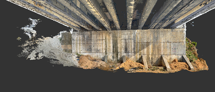
Here a screenshot of a 3D model I got by mixing Pix4DCatch and pictures with the best resolution with the Photo App iPphone, computed with Pix4DMapper:
I used tie points and GCP. But I got difficulties because of a bad georeferenced pictures with Pix4DCatch which were absolutely not well oriented.
The result is better than the Pix4DCatch alone + Pix4DMapper but request more time, first to point out GCP and tie points in the 2 set of pictures, second to compute the whole project.
@ totalsurvey2-xxx What was your purpose, if I can ask?
- What went wrong in this project?
- Is there the possibility to choose some images and discard others on “cloud”, like in desktop version?
My purpose was:
1- test the Pix4DCatch workflow + Pix4DMapper (Web & Desktop)
2- compare the results in both cases which were:
- Pix4DCatch + Pix4DMapper (Web),
- Photos with iPhone full resolution + Pix4DMapper (Desktop).
3 - integrate 3D model points cloud in Acad work for helping to construct and control 3D volume
Note that the bridge has been surveyed with traditional methods (total station) to construct the 3D volumes (piles, beams etc…).


