PIX4Dcloud supports the export of annotations in DXF format in the project coordinate system.
The export is very easy to do and very flexible so that only the selected layers and annotations will be exported.
There are two different options:
- Multiple annotation layer export by clicking the icon on the top of the hierarchy
- Single annotation layer export by clicking the icon on each of the layers
As an example, the DXF export will be as explained below with the following layers and annotations selected:
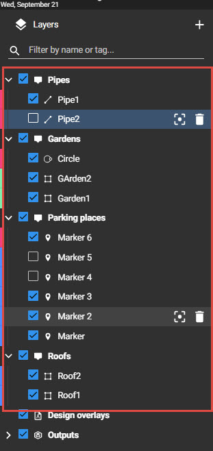
-
The multi annotation layer export will generate:
- A single DXF file with four layers named:
- Pipes → Including one line (Pipe1)
- Gardens → including one circle, and two polygons
- Parking places → Including 4 markers (markers will be represented by a cross)
- Roofs → Including 2 polygons
- A single DXF file with four layers named:
-
The single annotation layer export in layer “Pipes” will produce
- A single DXF file including one line and one single layer called “Pipes”
In both cases the DXF (compatible with any CAD software) will include 3D information and it will be given in the same coordinate system as the project.