Hola! un gusto saludar!! espero se encuentre bien!
Estoy procesando datos de la cámara Micasense Altum y me da ese error:
[Error]: Generating tiles failed!
[Error]: >>>Generating tiles<<< failed with error (failed to run a step!)!
[Error]: >>>Generating tiles<<< failed with error (failed to run a step!)!
[Error]: Processing group LWIR failed!
[Error]: >>>Processing group LWIR<<< failed with error (failed to run a step!)!
[Error]: >>>Processing group LWIR<<< failed with error (failed to run a step!)!
[Error]: Dense Processing failed!
[Error]: >>>Dense Processing<<< failed with error (failed to run a step!)!
[Error]: >>>Dense Processing<<< failed with error (failed to run a step!)!
[Error]: Dense matching failed!
[Error]: >>>Dense matching<<< failed with error (failed to run a step!)!
[Error]: >>>Dense matching<<< failed with error (failed to run a step!)!
Hello Eddison,
Can you attach the project log file as well as the quality report? These will tell us much about your project and what might be going on. We will take a look at them and see what we can do.
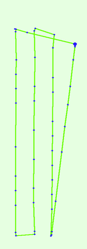
Thank you for uploading. I believe the problem has to do with your image acquisition. There appears to be inconsistencies with the image overlap. The images should be at a very regular intervals. In your case the images appear to have a very random spacing and as a result the overlap will be inconsistent.
This can be a big problem with thermal bands since the resolution of thermal is very low. When trying to create thermal maps we recommend using very high overlap. Perhaps 90% both frontal and side.
I hope this helps.
80% might be fine but your image acquisition is inconsistent. The blue dots are where the images were taken. They should be at very regular intervals. Instead they are grouped tighter in areas and in other areas the gaps are bigger. So your overlap varies throughout your project. This will cause problems.
I suggest reflying and increase to 90% and make sure the overlap is consistent throughout your project.
Hola!! gracias, lo extraño es que hemos revisado los parámetros en la cámara Micasense Altum en http://192.168.10.254 y los parámetros están bien… se indica claramente un traslape de 80 % a 30 metros de altura.
¿Que estará pasando con la captura de imágenes con la Altum? que la toma a intervalos no regulares?
The image exif tags clearly indicate irregular spacing of the images. Because thermal resolution is very low it requires the overlap to be 90% in order for sufficient keypoint to be generated. Because there are gaps the overlap will drop in those areas.
Please reference our support article on how to process thermal imagery:
Si entiendo perfectamente! pero algo pasa con la Altum entonces… dado que no está tomando las fotos de manera regular… con el traslape que se le ordena.
These cookies are necessary for the website to function and cannot be switched off in our systems.
They are usually only set in response to actions made by you which amount to a request for services, such as setting your privacy preferences,
logging in, or filling in forms. These cookies do not store any personally identifiable information.
These cookies allow us to count visits and traffic sources so we can measure and improve the performance of our site.
They help us to know which pages are the most and least popular and see how visitors move around the site.
All information these cookies collect is aggregated and therefore anonymous.
If you do not allow these cookies we will not know when you have visited our site, and will not be able to monitor its performance.
These cookies may be set through our site by our advertising partner (Google).
They may be used by Google to build a profile of your interests and show you relevant adverts on other sites.
They do not directly store personal information but are based on uniquely identifying your browser and internet device.
If you do not allow these cookies, you will experience less targeted advertising.