This is what all surveyors in the US use. It has been requested and overlooked for too long. Pix says that this is for surveyors, so… This is a huge overlook.
I think what you’re looking for is available in PIX4Dmatic, might be worth to give it a try. Here is a screenshot that shows you can select from “m”, “ft” or “ftUS” for the Arbitrary Coordinate Systems. You can download the software here: https://www.pix4d.com/download/pix4dmatic. There is a free trial.

Another advantage is that you have all the geoid support for the US in PIX4Dmatic such as GEOID12B, more about that here: https://support.pix4d.com/hc/en-us/articles/360044174411-How-to-use-vertical-coordinate-systems-and-geoids-in-PIX4Dmatic
Let me know if you try it out.
Thank you Pierangelo!
Why are more customizable coordinate systems/units/geoids only available in Pix4dMatic and not Mapper?
I’d like to know the answer to this question also.
Hi @mquinn and @Andrew_Milanes ,
You can also choose the unit of the coordinate system for both GCPs/MTPs and images in PIX4Dmapper

Best regards,
Rosana
Hi Rosana, yes I am aware of setting feet or meters for measurement units. The topic of the original post was the point that US Survey Feet is not an option when this program is used by so many surveyors or survey applications. My question specifically asked why Matic would allow for customizable geoid and offer USft but Mapper does not (and also why a utilizing a local coordinate system is all but impossible in Mapper).
Right, show me where US Survey Ft is on that list. It is a glaring omission for a software making the claims that mapper is making. And, it would seem from the post above, the answer is to spend more money on a product that I don’t want.
Thanks Pierangelo, but I don’t want to spend more money, I want the software that I originally paid 9k for and continue to pay $750 per year plus a monthly cost for cloud… to support US Survey Ft and NAVD88 in local coordinate systems. Honestly, don’t you agree that the software should support this? I have to transform GCPs from USFT to International feet to process, then take the products from mapper back in to Global Mapper again to transform them from International to USFT. And because Pix Cloud doesn’t like the DSM that Global Mapper generates, I can’t ever upload DSMs.
All of this could be avoided if… ![]()
Chris, I agree 100%. Hopefully Pix4D will add geoid support soon. It’s needed.
Hi all,
Thank you all for your replies.
It is my understanding that PIX4Dmapper does take the US Survey Feet into the account. Once the unit is switched switch to ft, it depends on which coordinate system is being used for the project. However, I understand if there is a specific coordinate you wish to use but not in US survey feet, feel free to let us know which coordinate systems you would like to see US Survey Feet being incorporated into PIX4Dmapper. We appreciate this feedback and will be keeping in mind this feature request.

The GCPs error is also being shown in the US survey foot

In the log file, the unit will also be indicated with the exact measurement after running step 1. I attach this screenshot of a log file as an example.

I understand if this measurement could be not something everyone is looking for. It is a friendly remember of where to know the exact measurement and check if this suits your need.
Here are some useful resources:
How to get the Pix4Dmapper Measurements in feet
Once again, thank you all very much for your feedback on this.
Sincerely,
Rosana
Rosanna,
Feel free to reach out to me for a Teams meeting. I can share my screen to show you where the issue is and explain why it’s a problem.
Pierangelo,
I deselected the solution checkmark because I don’t think that the problem has been resolved. I truly believe that this issue should be resolved within Pix4d Mapper.
To this point, it has felt; for a while now, that Pix4d Mapper is not receiving new tools and updates… Almost as if it is being phased out. There are multiple features that have been requested over the years and have been seemingly ignored, or at least deprioritized in regard to the development of web-based services that Pix has introduced. I’ve been using Mapper since the Pix4UAV days and am saddened by the loss of momentum.
If my analysis is incorrect, please feel free to contact me.
Good afternoon @Chris_Putnam,
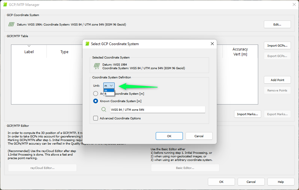
for my understanding of the replies posted by @Rosana_Lin , she is actually confirming that USft are Supported Units both for GCPs and Images in Pix4D Mapper: honestly it is not so intuitive (first you need to select a generic “ft” in Units, and only when you start to search for a Known Coordinate System, you will finally find some of them in USft), but it is possible.
Attached a screenshoot of the above mentionned option:

However, if what your are experiencing is a lack of Automatic Recognition of the Coordinate System in USft just when you are importing the images, in that case I’m not able to confirm that, because I live too far from a USft Coordinates Zone.
Sincerely,
Giancarlo
What about geoid support? This has not been addressed. And please don’t tell me to use Pix4DMatic. I have a perpetual license for Pix4DMapper. Either keep developing Mapper or deprecate it. You can’t have it both ways. Why am I paying for maintenance if the software is not being developed? It’s frustrating.
@giancarlo.patierno, I’m specifically referring to the arbitrary coordinate system option that I have to use for local coordinate systems. That is where the lack of USFT as an option is problematic. I’m not referring to known systems.
I concur. I pay $750/yr for support and maintenance. The low bandwidth in my region necessitates on-prem processing. I don’t want to be told to use Matic to resolve the problem either.
Glad to see I’m not the only one sharing in this frustration. I’ve been requesting the ability to use different (non-global) geoids for nearly 7 years now. The only workaround they’ve suggested was to use another program to convert the coordinates. That’s all fine and dandy, I then enter into utilizing arbitrary input and output coordinate systems, which works as long as you’re using an XYZ file for exports instead of an LAS/LAZ, and you don’t mind your orthoimage being by 6’ off when working in state planes. Using this program seems to be a vicious cycle of workarounds, definitely not where I thought it would be at by now when I started using it back in the Postflight Terra3D days.
No doubt.
I finally purchased Pix4DMatic, and am a bit dissapointed that a coordinate system can’t be set in Matic without importing GCPs, which is unfortunate because I have clients who just want the imagery or want to look at their roof in 3D and don’t want to pay for survey, but I can’t convert it to a CS using ft or usft without importing control in Matic or Pix4DSurvey.