Hi,
From the ground surveyors using total stations or DGPS systems or RTK systems, two types of formats are possible to provide the data in ie either ground scale or grid scale. What is the format in which Pix4D wants the GCP measurements in grid scale or ground scale? I’ll have to accordingly ask the surveyor to provide me the GCP measurements. Or is there a setting in Pix4d where I can set this info for processing?
Thanks,
Suhas
Hi,
Here are a few points to consider that can help you decide what type of format to choose:
- There are three coordinate systems that can be defined in the software: image coordinate system, GCP coordinate system and output coordinate system. By default the GCP and output coordinate systems are the same.
Hence, one way to decide what format you use, would be to know what your client would like to have as output coordinate system. Here is an article about how you can check that the correct coordinate system is selected for GCPs:
https://support.pix4d.com/hc/en-us/articles/203032299-How-to-verify-that-the-GCP-Geolocation-and-the-GCP-Coordinate-System-are-Correct
- Manufacturers of GPS devices with which you measure GCP coordinates certify a certain accuracy on the device. This accuracy could be for a certain coordinate system or file format.
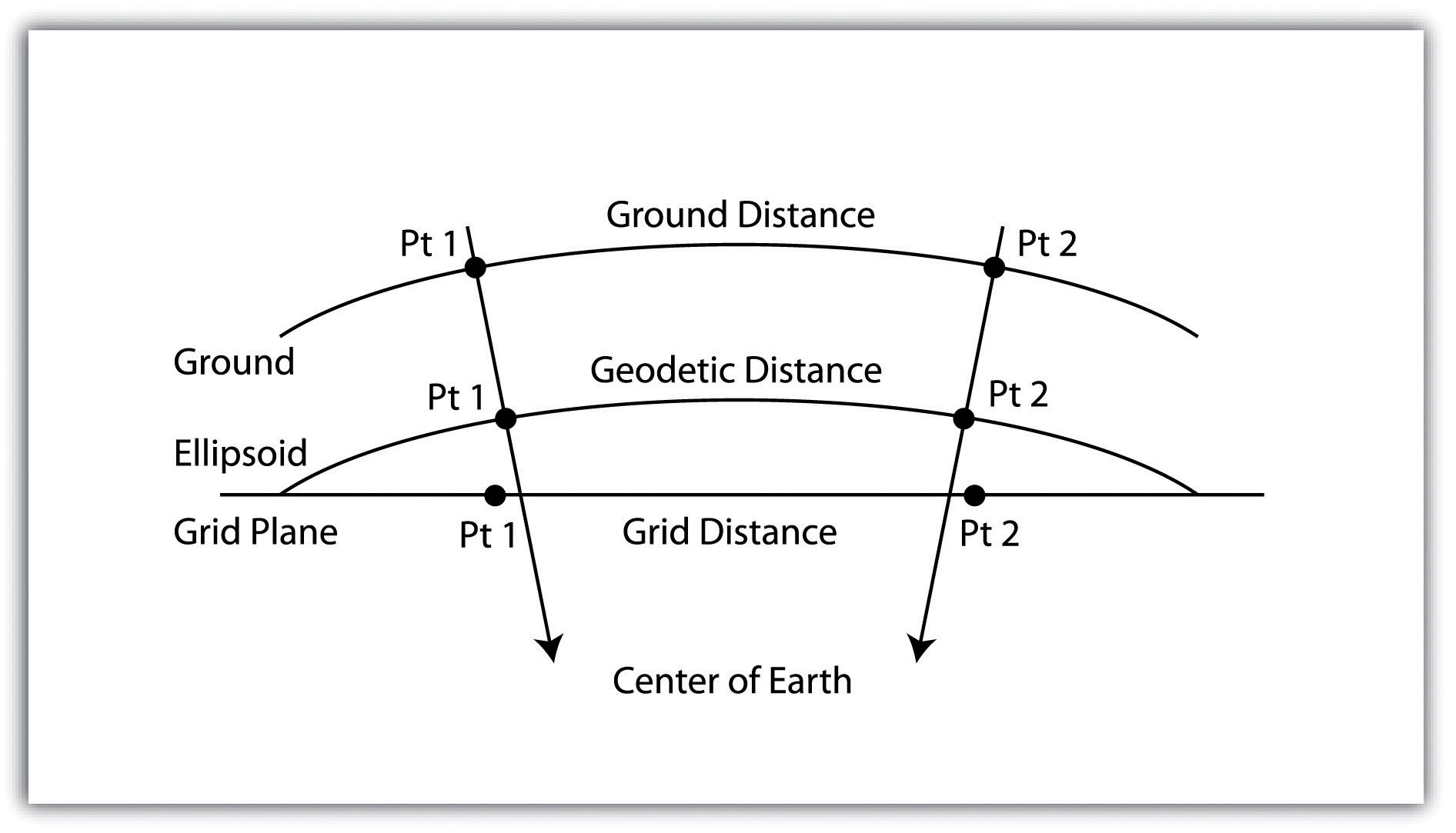
- It could depend on the type of project you have and what kind of output you want, e.g. do you want to measure a distance on the ground or on the grid?
Hi Pierangelo,
Thanks for your reply. Kindly let me clarify further:
-
Our input image coordinate system for geotags is : WGS84, ellipsoidal height; GCP coordinate system is: WGS84 UTM some zone, MSL height; Output coordinate system is WGS84 UTM some zone, MSL height again. These settings are clear to me.
-
The surveyor is giving me the option to give the GCP values on grid as well as ground scale as per my choice. The question is for the above coordinate systems settings, if I input the GCP values in either of these scale formats, would it not matter? OR does the WGS84 UTM coordinate system expects a particular format from these?
-
I am thinking that if I do measurements on this output coordinate system, it would mostly be in grid scale. Can you please confirm this? Also, if that is the case is it possible to get this output coordinate system on ground scale using some kind of transformation may be? Or what do I need to change in the coordinate system setting or elsewhere to change my requirement of doing measurements on ground or on the grid?
Thanks,
Hi Suhas,
If you define the GCP coordinate system as “WGS84 UTM some zone, MSL height” you should setup your GPS device so that it does the measurements directly in that coordinate system.
If you would do measurements in another coordinate system than the one that is defined in the project, there will be a mismatch and the software will not be able to correctly use the information.
Suhas,
I am a Surveyor with over 20 years of experience with GPS and coordinates systems, hopefully I can explain a little for you. Coordinate systems can difficult to explain in couple paragraphs.
Your surveyor is asking if you want in ground or grid, because ground is what is used in the (real world) if you were in the field measure with a tape . Grid is a measurement from a projection which will have different scale factors applied to your measurements, depending on where you are with in the projection. So if you are using your data for design and you are trying to measure in the real world ground distance, you will want your output coordinate system to a coordinate system that is at ground or real close with small amounts of distortion, like a LDP (low distortion projection).
Most of your out of the box coordinate systems like State Plane, UTM and etc… are for large areas covering many hundreds of kilometers. Which is good for planning over large areas. So if you are exporting to a UTM coordinate system and you measure on the screen a 100 feet, that is not 100 feet like you would measure on the ground with a tape measure. You would have to figure out what the scale factor is and apply to get your ground measurement.
LDP (low distortion projection) are being used a lot for smaller area like a city or county wide coordinate system. Which closer to ground measurements and almost eliminate a need to scale measurements, So that you can mix gps measurement and terrestrial measurement with out much difference, unlike if you are trying to mix UTM coordinates and Terrestrial measurements.
So if the city is your working in has a local coordinate system using a LDP, then I would use that as your output coordinate system. Pix4d will let you choose a prj coordinate system file. A prj file is an text file that give all the coordinate system variables, which can be created in third party software, like Esri and etc… or get from someone that has all ready created the file.
If there is not one available in your area, you can create your own or use PIX4D site calibration options so that you can calibrate to ground coordinates.
Might want to contact your surveyor and ask for his assistance. Show him your options in PIX4D and they should be able to help you.
Good Luck and have a good day.
Anthony
This is troublesome for me as well.
Geoidal and ellipsoidal translations hurt my brain, ouch.
Thanks Anthony for your insights! We can learn a lot from your experience.
Thanks a lot Anthony for those details. Really insightful.
As you rightly suggested, I just recently figured out how site calibration feature of Pix4D can be used for my problem i.e. Geotags in WGS84 and GCPs in some arbitrary Ground distance based coordinate system. It worked all perfectly.
I also figured that .prj file should be able to solve my purpose as well but could not understand how to do that in my case. I’ll look into it further and try creating it for my current project.
Thanks again.