Hello everyone,
I am struggling with the coordinate system setup in Pix4Dmapper.
In Pix4D I set the project and GCP coordinate systems as follows:
-
Horizontal: ETRS89 / UTM Zone 32N
-
Vertical: Geoid height over GRS 1980 ellipsoid with an offset of +44.8 m (this value was taken from the quasigeoid map of Germany: Quasigeoid der Bundesrepublik Deutschland).
Problem:
After entering the GCPs and running reoptimization, I always get the warning:
“One or more GCPs are far away from the image positions. Please make sure you selected the correct coordinate system.” (Warning w0025).
My question:
How should I set the project coordinate system and the GCP coordinate system in Pix4D so that I can use the surveyor’s coordinates (ETRS89/UTM32 + DHHN2016) and the reoptimization works correctly?
Thanks a lot for your help!
Hi @thea.blaettermann,
Welcome to the Pix4D Community  .
.
Please note that PIX4Dmapper only supports global geoids (EGM 2008, EGM 84, and EGM 96).
You can find more info here:
If you use an offset to Geoid height over GRS 1980 ellipsoid, the same offset will be used over the same project (no large scale ondulation taken into account). This can work if the area is not too large.
Alternatively, you can use PIX4Dmatic, which supports DHHN2016 (let me know if you are interested in a trial license for PIX4Dmatic).
Generally speaking, the project CRS and GCPs CRS are independent:
- Images CRS should match the CRS of the coordinates saved in the images EXIF/XMP tags.
- GCPs CRS should match the CRS used to retrieve the points.
- Project CRS is the one that you want to use for your outputs. Usually, it’s the same as the GCPs CRS. If it is different than the GCPs GRS, PIX4Dmapper will make the necessary transformations.
Your error indicates a large distance between the images and the GCPs.
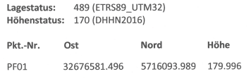
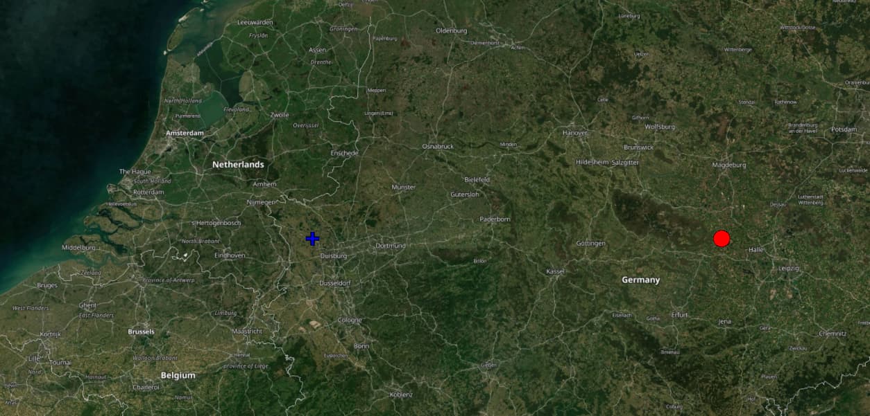
I tried to plot PF01 using ETRS89_UTM32, and it is not appearing in Europe. Could you verify with your surveyor if these coordinates are correct, or if the CRS used is EPSG:25832?
Could you please share a screenshot of the Map View showing the location of your images and the GCPs?
Let me know if this helps.
Kind regards,
Daniele
Hi Daniele,
thanks a lot for your quick response! I’ll check in with our surveyor and share an update as soon as I have more details.
While checking the Quality Report, I noticed that it is mainly the X value that looks unusual. I tried experimenting a bit with the coordinates — instead of 32 676 581.496 I entered 326 765.81 — and this brought me closer to my image coordinates (see attached screenshot). However, the GCPs are still positioned slightly too far west.
I will update you once I have feedback from the surveyor.
Best regards
Hi @thea.blaettermann
Thank you for your reply and the screenshots.
It seems that the “northing” is exactly the same for GCPs and images.
Is the location of the images correct (south of Magdeburg, west of Halle)?
If yes, the “easting” in that area should be around 67x’xxx and 68x’xxx.
I will wait for you to get feedback from the surveyor.
Kind regards,
Daniele
Hi Daniele,
After discussing the issue with the surveyor, I learned that my GCPs were actually provided in EPSG:3044 rather than the expected EPSG:25832.
The key difference is that in EPSG:3044, the zone number 32 is added to the Easting, which produces 8-digit values (e.g. 32 676581.496).
The fix is straightforward: simply subtract 32,000,000 from the Easting. For example:
32676581.496 – 32000000 = 676581.496.
This matches your assumption, Daniele, that the Easting values in this region should fall within the range of 67x’xxx to 68x’xxx.
Once this adjustment is made, the coordinates align correctly. At that point, it makes no practical difference whether the project in Pix4D is set up as EPSG:3044 or EPSG:25832, since the coordinates now match. After correcting and importing the GCPs, I was able to reoptimize the project without issues.
Thanks a lot for the help – the problem is now resolved!
Hi @thea.blaettermann ,
Thank you for your answer. I’m happy to hear that this is resolved.
I will also close the support ticket you opened the other day.
Let me know if there is anything else I could do for you.
Kind regards,
Daniele