I typically try to use at least 7-10 GCP’s for each flight. I measure each GCP using a GNSS base and rover to gather the coordinates. I am flying the sites with a Phantom 4 RTK drone with an RTK Base station. I am concerned that my verticals are not accurate. What is an acceptable lever of error. I have run many projects with varying levels percentages of error. I just recently processed a flight and I am not sure the point cloud is accurate at all.
What am I doing wrong? Is the something in how I setup to fly? What values should I be seeing if everything was processed correctly?
Hi Trent,
How are the GCPs’ Z errors looking? Is there any outlier that is causing this error? Could you share the entire quality report (.pdf)?
Best regards,
Rosana (she/her)
My GCP report didn’t look that bad to me.
1456 Bluestream Pond 02-23-23_report.pdf (2.3 MB)
Can you at least provide some guidance on what an acceptable Absolute Geolocation Variance should look like? I have no idea what levels are too high or low.
I guess I’m on my own. Thanks.
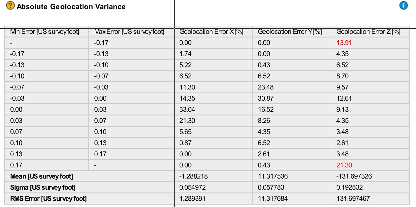
Hi @thargis, you can check here what an expected distribution of values would look like.
One of the reasons why you would get unexpected geolocation errors is if the accuracy of some coordinates has been overestimated.
#GCP accuracy values

Can you confirm that your project’s GCPs were measured with the following accuracy? 0.02 US survey foot, horizontally (XY) and vertically (Z)? If not, I recommend you either get the real values from the tool you used or change them to a number closer to 0.06 US survey foot.
I am asking because 0.02 is the value automatically populated in the GCP table when there are no accuracy values in the imported file and when the project’s unit is in the metric system. However, while you project is in feet, I suspect that the table was populated by accuracy values of “0.02” instead of “0.06”, the converted value for US survey feet. In that case, we may have uncovered a bug so it would be very helpful if you could confirm.
#Image geolocation accuracy
Can you confirm that you indeed expect these image geolocation accuracy values?

0.035987 US survey foot horizontally (XY) and 0.090186 US survey foot vertically (Z). These values are averages of the values in the Image Properties Editor’s table.
if you are not confident that the accuracy values do not reflect your image geolocation accuracy, I recommend you change them to value that better reflect the theoretical accuracy of your GPS.
In both cases, you would need to reoptimize your project.
Let us know how it goes.