# DSM shows high vegetation in the contours file.
**URL:** https://community.pix4d.com/t/dsm-shows-high-vegetation-in-the-contours-file/22619
**Category:** PIX4Dmapper
**Created:** [May 17, 2022, 12:04pm UTC](https://community.pix4d.com/t/dsm-shows-high-vegetation-in-the-contours-file/22619 "2022-05-17T12:04:27Z")
**Posts on this page:** 13
**Page:** 1
### Author:  [@joe.gatti](https://community.pix4d.com/u/joe.gatti)
#### Post date: [May 17, 2022, 12:04pm UTC](https://community.pix4d.com/t/dsm-shows-high-vegetation-in-the-contours-file/22619/1 "2022-05-17T12:04:27Z")
DSM shows high vegetation in the contours file. Looking at the point cloud the vegetation is classified correctly but it’s still showing up in the contours file.


Seems to remove some but not all any guidance would be appreciated.
Thanks
Joe
---
### Author:  [@Daniele\_Lecci](https://community.pix4d.com/u/Daniele_Lecci)
#### Post date: [May 19, 2022, 7:59am UTC](https://community.pix4d.com/t/dsm-shows-high-vegetation-in-the-contours-file/22619/2 "2022-05-19T07:59:23Z")
Hi @joe.gatti,
Thank you for your question and welcome to the Pix4D Community 🙂.
Yes, the contour lines are taking into account the Digital Surface Model (DSM) if no Digital Terrain Model (DTM) is generated. You need to enable the DTM generation as only the _Ground_ and _Road Surface_ groups are preserved in the DTM.
You can find additional information here:
> **[How to generate the contour lines](https://support.pix4d.com/hc/en-us/articles/202560639-How-to-generate-the-contour-lines)**
>
> IN THIS ARTICLE
> What are contour lines? Generated with the digital surface model Generated with the digital terrain modelDuring processing step 3. DSM, Orthomosaic and Index with the digital su...
Happy mapping!
🙂
---
### Author:  [@joe.gatti](https://community.pix4d.com/u/joe.gatti)
#### Post date: [May 19, 2022, 6:08pm UTC](https://community.pix4d.com/t/dsm-shows-high-vegetation-in-the-contours-file/22619/3 "2022-05-19T18:08:48Z")
Hi Daniele,
Thanks for the response. I have those setting checked in option 3, see below.
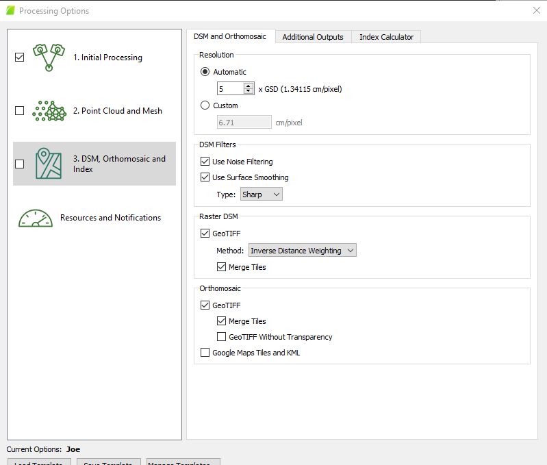

Am I missing something?
I did watch the video on that link just so you know.
I’m running version 4.8.0 if that makes any difference.
Thanks
Joe
---
### Author:  [@Daniele\_Lecci](https://community.pix4d.com/u/Daniele_Lecci)
#### Post date: [May 20, 2022, 8:35am UTC](https://community.pix4d.com/t/dsm-shows-high-vegetation-in-the-contours-file/22619/4 "2022-05-20T08:35:30Z")
Hi @joe.gatti
Thank you for your reply.
Could you please open your DTM to see if it shows the vegetation?
(click **Mosaic Editor** on the left sidebar \> Select **DTM** in the droplist at the top of the PIX4Dmapper window) The DTM will appear with a color scale.
You can also try to use a different _Surface Smoothing_ in the DSM Filters.
Also, did you enable Point Cloud Classification in _step 2_?

---
### Author:  [@joe.gatti](https://community.pix4d.com/u/joe.gatti)
#### Post date: [May 20, 2022, 1:27pm UTC](https://community.pix4d.com/t/dsm-shows-high-vegetation-in-the-contours-file/22619/5 "2022-05-20T13:27:01Z")
Hi @Daniele_Lecci
Yes I do have classify point cloud checked. The DSM and DTM both look pretty good to me see below.
DSM

DTM

I’ll try changing the filter and see if that does any good.
Thanks again for the help.
Joe
---
### Author:  [@Daniele\_Lecci](https://community.pix4d.com/u/Daniele_Lecci)
#### Post date: [May 20, 2022, 2:17pm UTC](https://community.pix4d.com/t/dsm-shows-high-vegetation-in-the-contours-file/22619/6 "2022-05-20T14:17:16Z")
Hi @joe.gatti,
Thank you for the screenshot.
Yes, the DTM looks smoother than the DSM, but part of the vegetation is still visible (image below)

Only the _Ground_ and _Road Surface_ groups are preserved in the DTM. To improve the DTM, all the terrain points should be assigned to one of these point groups. To manually move points between the automatically generated point groups, the **Edit Densified Point Cloud** option can be used: [How to edit the point cloud in the rayCloud](https://support.pix4d.com/hc/en-us/articles/202560499-How-to-edit-the-Point-Cloud-in-the-rayCloud#gsc.tab=0). If the point cloud classification has not been generated, which is not recommended, all the points are treated as non-terrain points and the DTM is a smoothed version of the DSM.
You can find additional information here:
> **[How to automatically generate a Digital Terrain Model (DTM)](https://support.pix4d.com/hc/en-us/articles/202560579-How-to-automatically-generate-a-Digital-Terrain-Model-DTM)**
>
>
>
> Video: Watch the instructional video related to DTM:
>
>
>
>
>
> Important: The DTM is significantly improved when the point cloud classification is used: How to generate the point cloud classificatio...
---
### Author:  [@joe.gatti](https://community.pix4d.com/u/joe.gatti)
#### Post date: [May 20, 2022, 3:46pm UTC](https://community.pix4d.com/t/dsm-shows-high-vegetation-in-the-contours-file/22619/7 "2022-05-20T15:46:09Z")
Hi @Daniele_Lecci,
I’ll give that a try and let you know how it goes.
Thanks again.
Joe
---
### Author:  [@joe.gatti](https://community.pix4d.com/u/joe.gatti)
#### Post date: [June 1, 2022, 7:40pm UTC](https://community.pix4d.com/t/dsm-shows-high-vegetation-in-the-contours-file/22619/8 "2022-06-01T19:40:34Z")
Hi @Daniele_Lecci
I tried editing the point cloud to make sure everything was assigned to the correct category but still get the same results in my contours file. Here’s another example.
Mosaic:

Point Cloud:

DSM:

DTM:

Contours:

Processing settings:


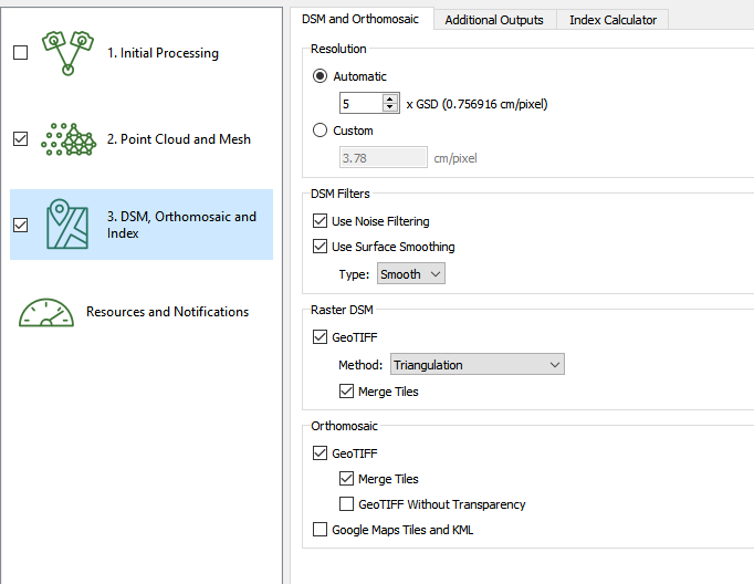

What am I doing wrong? The contours file would be great if I could get rid of the tress and man made stuff and it’s a lot cleaner than the contours file that come out of Drone Deploy but until I can get this resolved I’ll have to use the Drone deploy one when there’s high vegetation on the sites I’m flying.
Any help would be greatly appreciated.
Thanks
joe
---
### Author:  [@Daniele\_Lecci](https://community.pix4d.com/u/Daniele_Lecci)
#### Post date: [June 2, 2022, 3:44pm UTC](https://community.pix4d.com/t/dsm-shows-high-vegetation-in-the-contours-file/22619/9 "2022-06-02T15:44:22Z")
Thank you for all the new information, @joe.gatti.
Please try to assign the points belonging to vegetation and buildings to the “disabled” group and process the DTM again.
In fact, the DTM interpolation:
- Takes into account all of the points in the densified point cloud except points that you assign to the Disabled point class.
- Applies little to no smoothing to points that you assign to the Ground or Road Surface point class.
- Applies smoothing to points that you assign to the Unclassified, High Vegetation, Building, Human-Made Objects, or any other point class.
You can find additional information here:
> **[How to automatically generate a Digital Terrain Model (DTM)](https://support.pix4d.com/hc/en-us/articles/202560579-How-to-automatically-generate-a-Digital-Terrain-Model-DTM)**
>
>
>
> Video: Watch the instructional video related to DTM:
>
>
>
>
>
> Important: The DTM is significantly improved when the point cloud classification is used: How to generate the point cloud classificatio...
---
### Author:  [@joe.gatti](https://community.pix4d.com/u/joe.gatti)
#### Post date: [June 2, 2022, 5:36pm UTC](https://community.pix4d.com/t/dsm-shows-high-vegetation-in-the-contours-file/22619/10 "2022-06-02T17:36:39Z")
Hi @Daniele_Lecci,
I don’t suppose there’s a easy way to do that…like click on the points classified as high vegetation and disable them all at once? Or I have to manually outline each thing and disable it? If that’s the case it seems like it would be a waste of time classifying the point and generating the DTM automatically in the processing option.
Thanks again for the help.
---
### Author:  [@Daniele\_Lecci](https://community.pix4d.com/u/Daniele_Lecci)
#### Post date: [June 3, 2022, 9:02am UTC](https://community.pix4d.com/t/dsm-shows-high-vegetation-in-the-contours-file/22619/11 "2022-06-03T09:02:39Z")
Hi @joe.gatti,
When you open the legend of the different classes, you can turn on/off selected classes.

Select only the `High Vegetation`, `Building`, and `Human Made Object` classes.

Assign the points belonging to these classes to the `Disabled goup`:
1. Select the **Edit Densified Point cloud** tool.
2. Draw a polygon in order to select all the points
3. Select the `Disabled` class
4. Assign the selected point to the `Disabled` class

Now you can create your DTM and contours.
Please let us know how it goes.
---
### Author:  [@joe.gatti](https://community.pix4d.com/u/joe.gatti)
#### Post date: [June 3, 2022, 1:00pm UTC](https://community.pix4d.com/t/dsm-shows-high-vegetation-in-the-contours-file/22619/12 "2022-06-03T13:00:13Z")
Hi @Daniele_Lecci ,
Ok, that looks much better. Still need to do a little tweaking but that will do the trick.
Thanks much.
joe
---
### Author:  [@Daniele\_Lecci](https://community.pix4d.com/u/Daniele_Lecci)
#### Post date: [June 3, 2022, 1:13pm UTC](https://community.pix4d.com/t/dsm-shows-high-vegetation-in-the-contours-file/22619/13 "2022-06-03T13:13:37Z")
Hi @joe.gatti,
I’m happy to hear that you are getting good results.
Happy Mapping!